
Creative Depictions of the Ringold Fm
- Aug 16, 2019
- 9 min read
Updated: Dec 26, 2024
Stratigraphy of the Ringold Formation of Eastern Washington (9.5-3.4 Ma) has recently drawn my attention. The Ringold is a young formation where the transition from unlithified sediments to lithified rocks is not yet complete. Also, no clear boundary exists between the uppermost Ringold (late Pliocene) and the lowermost Pleistocene sediments (<2.6 Ma). Sediments that comprise the Plio-Pleistocene transition are fairly fine grained and reflect a rather subtle geological transition from Pliocene (fluvial-lacustrine-fan system) to Pleistocene (Ice Age flood-loess system). Consequently, this portion of the strat column shows the greatest variability.
I am struck by the artistic creativity shown by geologists who have depicted Plio-Pleistocene strata in their reports. In the figures below, we see both innovative depictions by independent thinkers (reflecting frustration with older reports) and bureaucratic complacency (recycled images by Hanford staff).
Early reports on the Ringold, mostly from field geologists, are often more detailed and nuanced than later ones. Brown and Brown (1965) provide an example,
Work by Roedder shows that the mineral composition of the silt and clay fractions of the classifical Ringold Formation sediments steadily and systematically approach the composition of the silts and clays in the sediments between basalt flows. The lack of the break one would normally expect if an unconformity or major disconformity were present also helps substantiate the continuity of deposition...It is evident that the Ringold Fm extends back into time farther than predicated. Moreover, the lowermost sediments of that sedimentary sequence grade structurally and mineralogically into sediments of the lower Ellensburg Formation. Hence some of the Ringold Fm must be the equivalent to the upper or undifferentiated Ellensburg Fm. Probably the Ringold Fm overlaps the Ellensburg Fm in time, with the lowermost beds (the so-called "blue clays") representing the first pending resulting from the anticlinal uplift, and the equivalent of the fluvial Ellensburg Fm sediments. The White Bluffs exposures then represent the quiet and shallow water deposits northeast of the main stream deposits of the Columbia River.
By 1990, a basic framework for the Ringold was still being constructed by Lindsey and Gaylord (1990),
The Miocene-Pliocene Ringold Fm is an interstratified sequence of unconsolidated clay, silt, sand, and granule to cobble gravel that generally is subdivided into five laterally traceable lithostratigraphic units. The evaluation of borehole geologic and geophysical data and outcrops on and adjacent to the Hanford Site in south-central Washington suggests that this traditional model inadequately portrays the complex nature of the Ringold Fm.
By 1996, major stratigraphic breaks, facies associations, and a depositional model had been worked out (Lindsey, 1996).
Depictions of the Ringold today remind me of reconnaissance reports on foreland strata in Wyoming circa 1955. The cartoons, the thin description, the reliance on fuzzy well logs, the myopic focus on specific basins (i.e., Cold Creek syncline/Hanford 200 West Area), and the lack of regional perspective is all quite familiar.
Work on the Ringold continues today. Its connection to the upper Ellensburg as well as formations in NE Oregon, central Idaho, and Puget Sound remains to be fully worked out. A regional synthesis on post-Miocene tectonism, the routing of the ancestral Columbia and its tributaries, and the source-to-sink maps showing sediment routing are still needed.

Map by Kennedy/Jenks Consultants for the Franklin Conservation District, reported in Triangle Associates (2003) shows the extent of the Ringold formation in south-central Washington compiled from surface mapping and well log information. The color ramp (elevation) emphasizes an overall SW-sloping surface that has been locally warped across Yakima Folds and incised by rivers and Ice Age floods. Note the western margin appears truncated by the Columbia River. The Ringold originally extended farther west, north, and south.

Pasco Basin was never isolated and its sedimentary fill (Ringold Fm) records the work of big rivers, changes in accommodation space, and regional tectonics. This map by T.W. Symons (1882) of south-central Washington shows an outline of "Ancient Lake Lewis". Reconnaissance geologists of Symons' day tended to lump weakly-consolidated Pliocene and unconsolidated Pleistocene deposits into a single unit and call it "the John Day system". The early geologists saw a broad continuity in Tertiary basin-fill deposits of eastern Oregon, eastern Washington, and western Idaho. Local details were not their focus, but their observations have merit. Traveling on horseback or by Model T, pre-WWII field geologists had an excellent understanding of through-going rivers, alluvial deposits, and how large basins (region-scale sediment systems) can become clusters of small basins when waves of tectonism sweep through. Regional continuity of sedimentary systems (e.g., terrestrial sequence stratigraphy) is not emphasized in geology classrooms, articles, maps, or formation designations today, but should be. The lack of oil company experience and familiarity with the principles of sequence stratigraphy among geoscience faculty at PNW colleges remains an issue.

Stratigraphy for central Pasco Basin, WA (U.S. Department of Energy, 2002, Appendix A, Fig. A-2).

Mapping by Grolier and Bingham in the Lind Coulee area excerpted in Reidel and Campbell (1989). RIngold shown in dark stipple pattern.

Hydrogeologic units used in groundwater models of the unconfined aquifer at the Hanford Site (Cole et al., 2001, Table 3.1).

Ringold is classified as a sedimentary interbed. The figure infers Ringold sediments are, like the Levey Member interbed, a variant of the Ellensburg Formation, which is odd. For more than 70 years, Ringold sediments in the Pasco Basin have been described as supra-basalt basin-fill deposits. I think he problem is the author lumps the Ringold (not overlain by basalt) with Snipes Mountain Conglomerate (locally overlain by a young basalt flow). Much of the Ringold section clearly post-dates the youngest CRBs. Ebinghaus et al. (2020, Figure 2).

This figure was clearly drafted by committee and has been recylced in many Hanford Site reports. The first draft appears to be Bjornstad et al. (2001), which was built on decades of older stratigraphic sketches. A newer version is provided in Bjornstad et al./Department of Energy (2010). Williams et al. (2002, p. 3.1) describes why, unlike the rest of the geoscience community, Hanford staff use two different geologic columns to describe the same rocks, "Two separate Hanford Site stratigraphic classifications are available (Figure 3.1); one developed by Lindsey (1995) is based on lithology (labeled Geology Column), and the second, developed by PNNL (Wurstner et al. 1995; Thorne et al. 1993), is the hydrogeologic stratigraphy (labeled Hydrogeologic Column) that combines the geology with the hydrologic properties (see also Wurstner et al. 1995). [Hanford staff] uses PNNL’s hydrogeologic classification because it is more applicable to the problem of addressing groundwater movement in the suprabasalt sediments...This classification is consistent with the [coarse-resolution] three-dimensional computer models that use this classification and the revised hydrogeology report for the 200-East Area (Williams et al. 2000)".

Reidel and Chamness (2007, Figure 3.4, p. 3.8).

Badger and Galster (2003, Fig. 2) after Galster and Coombs (1989), which was modified from Mackin (161), Reidel and Fecht (1981), and Swanson et al., 1979). Note "fanglomerate" is placed entirely in the Ringold and is truncated by Pleistocene.

Note that 7.5 Ma is used for the base of the Ringold by Reidel et al. (2021, Figure 2).

Reidel and Chamness (2007, Figure 3.5, p. 3.10).
E.P. Gustafson (1978, Figure 3, p. 7). Note the prominent calcrete cap on the Ringold is not shown in the figure. "Lacuna" means "time gap" or the missing interval of time represented by the post-Ringold erosional unconformity (wavy line). This term has never been uttered by a geologist. Paleontologists use it. Gustafson named the Taylor Flat conglomerate (middle Ringold).

Note 5.3 Ma is used for the base of the Pliocene, but the Ringold is older than that (Carson, 2015, p.81).

Excerpt from Carson and Pogue (1997) for Walla Walla and eastern Pasco Basin area. Post-Ringold unconformity not shown.

Mustoe and Leopold (2014) separate the Ringold Fm into "Upper" and "Lower" parts along a sequence-bounding unconformity (Walpapi Synthem-High Cascades Synthem boundary) and an ecological shift from a warm, wet climate (hardwoods) to dry, cool climate (sagebrush) around 5 Ma. The location and interpretation of this break differs from Lindsey (1996) and Lindsey (2004).

Williams et al. (2002, Plate 10). An excerpt of a drilling log with hydrogeologic interpretation for Line 3 at the 200 West Area, Hanford Nuclear Site. The line represents a "south-to-north-oriented structural section located west of the 200-West Area that extends from the central axis of the Cold Creek syncline north onto the south flank of the Gable Butte anticline" (p. 4.12).

An example of Hanford's "functional geology" in Williams et al. (2002). I've resorted to calling it "functional" because Hanford's stratigraphic naming convention is not used outside of Hanford (though they so, so, so wish it were).

Smith et al. (2000, Figure 2, p. 6). A figure that juxtaposes two classic Ringold sections: White Bluffs and the Taunton Site railway cut. "l.f." = local fauna.


Reidel and Fecht (1994).

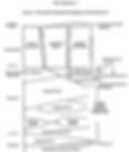
Dry sediments in the Hanford subsurface served for decades as a disposal site for defense-related chemical and radiogenic waste. This wouldn't be a problem except that the stuff moved beyond the vadose zone immediately, which wasn't predicted by Hanford scientists. In this cartoon, one effluent plume displaces another. Has anyone ever been fired from Hanford for incompetence? "Multiple-source contaminant plume conceptual model for the 200-West Area illustrating vertical displacement of pre-existing plume by more recent contaminant source" (Williams et al., 2002, Figure 4.12, p. 4.28).

"PP" is the calcrete-bearing "Plio-Pleistocene unit", which caps the Ringold Fm beneath the Hanford Site. A maze of natural cracks, voids, and permeable layers transmit effluent (leaked chemical waste) from the surface to deeper levels of the Ringold and the water table (Barnett et al. ,1997, Fig. 6.1). PP thickens to the south at the SALDS site. Cartoons were state of the art in the late 1990s at Hanford.

Lindsey and Gaylord (1990, Figure 1, p. 166). No shortage of unconformities here.

Stratigraphy of the 200 West Area (Bjornstad, 1990). Early 'Palouse Soil' (loess) is shown to post-date the calcrete-bearing Plio-Pleistocene unit.

Cooley (2019) modified from Hanneman et al. (2003) and Cheney (2016).

Grolier and Bingham (1978) show Ringold, capped by "caliche", lying unconformably atop eroded Columbia River Basalt.

Ward et al. (1997, Figure 1) modified from Caggiano et al. (1996)

Lindsey (1992, Figure 3).

Reidel et al. (1992, Figure 36, p. 41). Difficult to read. No calcrete mentioned.

Brown (1968, Figure 8). As late as the 1960s, the age of the youngest basalt/oldest Ringold was not known.

Reidel and Campbell (1989, Figure 3A, p. 280) introduce a "basal" unit to the Ringold. They divide the formation into 4 parts (not 3) on the basis of texture and describe the formation generally as mainstream and sidestream facies of the ancestral Columbia River system. The authors use "system" instead of "channel" because it was a large river, no single channel tract exists, and other large rivers conflued with the ancestral Columbia in an earlier version of the Pasco Basin, similar to today (Snake River enters at Pasco, WA). Reidel and Campbell's basal unit represents a "complete fining-upward fluvial cycle" deposited by a braided-river system (Snipe Mountain Conglomerate equivalent). The "lower " unit is lacustrine. The "middle" unit is composed of stream gravels also deposited by the ancestral Columbia River. The "upper" is the second fine-gained, low-energy lacustrine unit (laminated siltstones with thin sands).

Hartman (2012) frames the Ringold's hydrogeology in terms of confined and unconfined aquifers. Savage Island and Taylor Flat Members are not identified, but the Ringold Upper Mud (RUM) unit is. Figure also in Johnson (2016), a study on the 100-K/100-N reactor area located NW of Gable Mountain.

Reidel et al. (1992, Figure 10, p. 9).

Gustafson (2015, Fig 3, p. 7) depicts the White Bluffs in cross section. 1 = Lower White Bluffs local fauna, 2 = Upper White Bluffs local fauna, 3 = Blufftop local fauna, 4 = River Road local fauna, PG = Pleistocene gravel (outburst flood deposits), SL = Sea Level, WBT = White Bluffs Tuff.

Gustafson (2015, Fig 4, p. 8) shows the fossil location information (local faunas) alongside the lithology column. He found Bretzia fossils (Pliocene deer) in the White Bluffs Local Fauna within the "member of Taylor Flat". Other fossils of the White Bluffs Local Fauna include horse, bear, peccary, camel, rhinos, fishes, saber-tooth cat, canids, mustelids, and microtine rodents. The White Bluffs Tuff does not appear to be shown in this figure. Gustafson's previous articles always show it and use it as an important marker bed within the "member of Savage Island/Upper Ringold Fm". The Snipes Mountain Conglomerate, well exposed in Yakima Valley, is included here with the Ringold Fm. The "Lower Ringold Fm/Blue Clay level" is rarely exposed and known almost entirely from well logs. The "Blufftop Local Fauna" occur in the upper part of the 2nd of three consecutive lake-filling sequences in the Savage Island. Each lake begins with a diatomite bed. It is important to note the "member of Ringold Flat" in the left column is not the "Taylor Flat conglomerate" in the right column. This can be a significant source of confusion when reading the literature on the Ringold.

Lindsey (1992, Figure 4).

Bjornstad et al. (2010).

Mackley et al. (2021).

Lindsey (1992, Figure 6). Ringold shown deformed by Gable Mts anticline. White Bluffs at left (east).

Bjornstad and Lanigan (2007, Figure 2.2). Ringold in blue.

Hydrostrat at 100-H Tank Farm (Liikala et al., 1988)

Stratigraphy of 241-TX Tank Farm, Hanford Site (Wood et al., 2001, Fig. 2.3).


Fecht et al. (1985, Figure 13)


Tolan et al. (2002)

Wooded Island member by Lindsey (1996). Approximate timing: A.) <8.5 Ma, B.) 7.5 Ma, C.) 6.5 Ma, D.) 6-5 Ma.

Taylor Flat member by Lindsey (1996). Approximately 5 Ma.

Savage Island member by Lindsey (1996). Approximately 4.6-4 Ma.

Tolan et al. (2002) in Zentner (2018).

Reidel and Tolan (2013) in Zentner (2018).

Drainage system at 10 million years ago. Zentner (2018) with cartography by Manashtash Mapping.

Drainage system at 15,000 years ago. Zentner (2018) with cartography by Manashtash Mapping.

Excerpt from a GSA poster by Staisch and Sadowski (2021). Ringold shown in blue ("RG").

Fig. 6 from Staisch et al. (2021).

Excerpt from Staisch et al. (2021).
Lindsey et al. (2004, Figure 3)


Fecht et al. (1985, Figure 2)

Atlantic Richfield Hanford Co. (1976) and Bjornstad (1985) in Lasmanis (May 1989) in Washington Geologic Newsletter, v. 17


