
Two Terminal Moraines in Mission Valley, MT
- Nov 30, 2024
- 66 min read
Updated: 21 hours ago

INTRODUCTION
Glaciation of Mission Valley
The Cordilleran Ice Sheet invaded northwestern Montana multiple times during the Pleistocene, overtopping mountain ranges, widening pre-glacial river valleys, and depositing moraines composed of clay-gravel diamicts that often lack a full complement of boulders. Mission Valley is a structural trough that extends south of Flathead Lake between Polson, MT and the Ravalli Hill divide. Two prominent, horseshoe-shaped moraines indicate the Flathead Lobe occupied the valley floor at least twice during the past few hundred thousand years, while 2-3 generations of alpine tills merged with the ice sheet's lateral moraines along the west flank of the Mission Mountains or spilled onto the valley floor south. The older 'Mission' moraine extends from McDonald Lake north of Post Creek to Round Butte to the southern Moiese Hills. The younger 'Polson' moraine extends from Hellroaring Creek across the southern shoreline of Flathead Lake across the Flathead River gorge near SKQ/Kerr Dam to the Jette Lake bench and hills east of Loon Lake. Mappable surficial deposits therefor consist of two ice sheet tills, 2-3 alpine tills, sandy outwash gravel, varved beds of glacial Lake Missoula, debris flow deposits from the Missions, bouldery gravels in multi-storied bars along the Flathead River corridor (outburst floods), a flight of fluvial terraces along the post-glacial valleys of Post, Mission, Crow Creeks, and young sand dunes that march north and east. Bedrock in the area is Belt Fm. Tertiary basin-fill sediments are missing from the Mission Valley, apparently been scoured away by ice.
In this article, I review a century of published studies on the glacial geology of the Mission Valley published and present new evidence that shows the older, more southerly Mission moraine - not the Polson moraine - to be the true terminus of the Flathead Lobe. This article highlights a large archive of remarkably good work that was somehow overlooked by authors of geologic maps (i.e., Harrison et al. 1986; Lonn et al. 2007).

The Mission Mountains. View to the southeast over Big Arm bay of Flathead Lake to the Mission Mountains and Mission Valley. Pablo Reservoir is seen on the valley floor at center right. The Jocko River is in the hazy distance at right and marks the southern end of the study area. Photo taken from the road to Blacktail Ski Area above Lakeside, MT in 2021.

Recessional moraine concept. Glaciers form terminal or end moraines at their maximum-advanced positions (dark blue line). Less obvious are recessional moraines left behind during deglaciation (purple lines). Recessional moraines mark temporary pauses of a glacier in retreat. Recessional moraines are often less prominent than end moraines. The figure above is from Wyoming's Wind River Range and is used here to illustrate the recessional moraine concept. The record of ice advance and retreat in the Mission Valley, MT is more complicated, but generally follows the same pattern. I drew this figure.
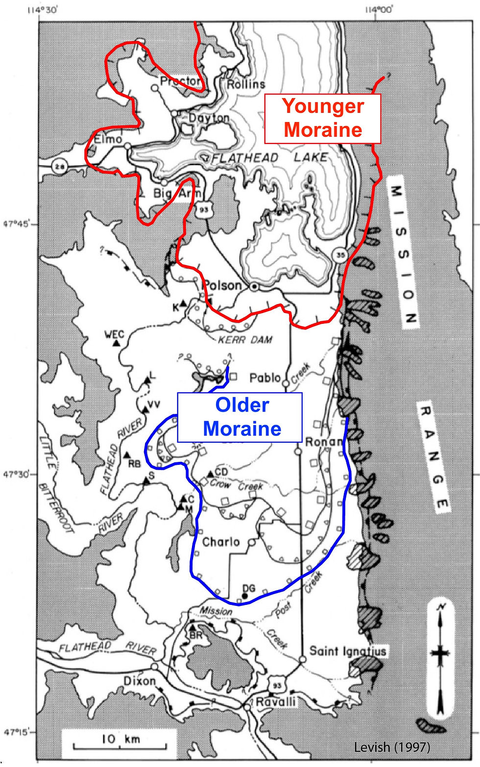
A testable hypothesis. Did the Flathead Lobe terminate at the Polson moraine (red), as many espouse, or farther south at the Mission moraine (blue), as indicated by the field geology? Are the tills south of Polson, MT late Wisconsin age (Pinedale glaciation, ~20 ka), early Pinedale age (~35 ka), or pre-late Wisconsin age (Bull Lake, ~130 ka)? Figure modified from Levish (1997).
Late Wisconsin Glaciation (MIS 2) - Most recent glacial advance in western North America. Roughly 35,000-11,700 years ago. Also called the 'Pinedale' Stage (Rocky Mts), 'Vashon' (Puget Sound), 'Fraser' (BC), and 'last glacial'.
Early Pinedale (MIS 4?) - Poorly defined glacial advance.
Bull Lake Glaciation (MIS 6) - The oldest glacial advance in the Rocky Mountains and PNW. Name applies mostly to the Laurentide Ice Sheet and eastern portion of Cordilleran Ice Sheet in Idaho and Montana. Age range varies, but something like 140,000 years ago seems reasonable. Approximates the 'Illinoisan' Stage recognized in the Great Plains. 'Double Bluff' in Puget Sound is likely the Bull Lake equivalent. Bretz's 'Spokane' glaciation might be Eastern Washington's Bull Lake and likely correlative with 'early Wisconsin' till in Glacier National Park. Named for Bull Lake, WY.

Mission Valley. The Mission Valley is located in northwest Montana south of Flathead Lake, west of the Mission Mountains, east of the Salish Mountains, and entirely inside the boundary of the Flathead Indian Reservation. The towns of Polson and Dixon mark the north and south ends of the valley. Map by Fremont (1848).

Mission Valley geography. Map by Daniel Levish (1993).

Former fluvial valley, then outwash plain, then lakebed, then patchy dunefield. Glaciers that sculpted the Mission Valley came in two forms. The larger Flathead Lobe of the Cordilleran Ice Sheet advanced south out of Canada and down the axis of the valley, while smaller alpine glaciers, sourced in cirques, descended the steep west flank of the Missions at right angles to the valley axis. End moraines of alpine glaciers lie below the uppermost strandlines of Glacial Lake Missoula and often appear to have been chopped off just before reaching the valley floor, first noted by Steere (1895). My photo looking south, taken near the Ronan Airport.
PREVIOUS STUDIES
Long history of geological investigation in Mission Valley
Native peoples certainly understood the geology of northwest Montana, even if written accounts are scarce. According to Blixt (1931),
...before the white man, the Indian showed himself a practical geologist: deposits of pipestone-clay and of obsidian and flint suitable for arrow heads were worked by him. The Snake Indians, in calling the territory which is now Montana...'land of the mountain', gave evidence of their observation of the broken and folded character of its surface.
Explorers David Thompson (c. 1812), Lieutenant A.J. Donelson (1853), Lieutenant Rufus Saxton (1853), and naturalist J.G. Cooper (1853-55) wrote extensively about the Montana landscape years earlier, but geologist T.C. Chamberlain was first to formally investigate Mission Valley's glacial history. In 1881, John Wesley Powell, the newly appointed Director of the fledgling U.S. Geological Survey, tasked Chamberlain with mapping the entire Pleistocene drift border from The Dakotas to the Atlantic Coast in detail - a monumental challenge by any measure (USGS 1883, 1889). Chamberlain, improving considerably on an earlier map by G. Frederick Wright (1892), published preliminary maps just two years later at a scale of 1 inch = 150 miles. They covered a swath of land only slightly reduced from the original plan (North Dakota to Cape Cod). Unfortunately, Montana's moraines were not mapped. Final versions were published in 1913.

First detailed map of America's glacial geology? Montana's glacial drift border is highly generalized in this early map in G.F. Wright (1892), 'Man and the Glacial Period'.

Loose outlines. Leverett's 1898 map offers a preliminary sketch of the glacial geology for the U.S. and Canada.
Through the 1880s, Chamberlain would continue to improve his drafts, working out the contours of end moraines and delineating what would eventually be called the 'Laurentide Ice Sheet' (USGS 1889, Chamberlain 1895, Flint 1943), the western edge of which butts up against the eastern entrance of Glacier National Park.
This region...was doubtless during a recent geologic period sheeted over with ice in a manner which finds a counterpart in the present condition of Greenland. This conclusion - and a similar one that has been reached with respect to certain portions of Europe - rests upon a vast mass of circumstantial evidence so clear and convincing when fully understood, that it may be regarded as one of the most wonderful and pleasing examples of inductive reasoning, and one of the best established that the whole range of modern science affords.
Despite dedicating several years to his work out West, Professor Chamberlain appears to have drawn no wage from federal coffers for it. In 1880, the USGS lists him as one of many "Expert Special Agents" working on a per diem of $5.00 per day. In 1889, Chamberlain confirms that while his assistants were fully supported for their mapping chores, he drew only a professor's salary from the University of Wisconsin and later from the University of Chicago.
Upham and Leverett have been employed continuously in the work of the Survey throughout the year; all others, myself included, have worked upon a per diem basis, in connection with other employment in the main educational.

Eastern limit of the Missoula Flood story. The Mission Valley is located in northwestern Montana at the south end of the Rocky Mountain Trench, where the Flathead Lobe of the Cordilleran Ice Sheet terminated. The valley extends south from Flathead Lake at Polson to the Ravalli Hill divide at St. Ignatius. The lake, the Mission Mountains, the divide, and the Flathead River form the valley's northern, eastern, southern, and western boundaries. Glacial Lake Missoula filled all of Mission Valley, leaving behind a blanket of varved silts atop tills and outwash as well as shorelines etched into untimbered hillsides. The valley is as far east as the Missoula Floods story goes. The eastern margin of the Cordilleran Ice Sheet at this latitude is also nearby, but somewhat loosely defined, spanning the Mission Mountains and the Swan Range. Original map by Waitt (1980).
Another University of Chicago professor, R.D. Salisbury and field geologists in his charge, G.H. Garry and E. Blackwelder, briefly visited the Flathead and Mission Valleys near the close of the 1800s (Salisbury 1901), confirming observations made previously by others,
The Flathead valley contained a great glacier which advanced southward beyond the southern end of Flathead lake, the southern limit of the ice was not traced out this season. In the latitude of Kalispell, the ice of this valley was about 3000 feet thick, as shown by the height to which the west face of the Kootenai Mountains [those of Glacial National Park] east of the valley, was glaciated. The general direction of ice movement in this valley at Kalispell...was south-southeast. The main body of the ice, therefore, came down the valley from the north northwest, and not from the mountains immediately east or northeast, though the main glacier was reinforced to some extent by ice from this direction. The source of ice which moved to the south-southeast was not determined. One lobe of the Flathead glacier moved southwest up the valley of Ashley Creek (the valley followed by the Great Northern Railway west of Kalispell), and another advanced westward a short distance beyond the end of the west arm of Flathead Lake.

Oregon Territory in 1849. Rivers, lakes, travel routes, and the general contours of mountain belts are shown on this 'Map of the Oregon Territory From The Best Authorities'. Flathead Lake and 'Lake Notre Dame' (Swan Lake) shown at right. Mission Valley in red box. Excerpt from Wilkes (1849, 2nd edition).

Railroads pioneer a route across Montana. Excerpt of an 1860 map from the Stevens Pacific Railroad Survey (1853-1855) 'Milk River to the crossing of the Columbia River'. Mission Valley indicated by the red box. The 'Trading Post' is Fort Connah. No one was thinking about glacial margins at the time. Map from the David Rumsey Collection.

Watersheds out west. 'Flathead Lake' appears on the 'Jocko Indian Reservation' in this curiously colorful map of 'drainage districts' by USGS (1891). No glacial margin shown. Map from USGS 11th Annual Report Part II, Plate LXIX.

Flathead Reserve. George F. Cram's Rail Road and Township Map of Montana (1878) is one of the earliest for Montana. Details include the Flathead Indian Reservation boundary and the Mission Post Office at Fort Connah.

Lands near the railway. By 1883, Cram's map adds considerable new detail, including in Mission Valley (red box).

Flathead River in 1853. Lithograph by the expedition artist Gustavus Sohon depicts the 'View of the Clark's Fork and the ridge of mountains, south of the Flathead Lake, looking eastward'. The artist was sitting on a hill a couple miles south of Sloan's Bridge, across the river from Moiese Valley. Low treeless hills in the middle distance are the Valley View Hills, Round Butte, and northern Moiese Hills. The Mission Mountains are on the horizon beyond. Source: Print 65, 12th Volume of 1860 War Department Reports of Explorations and Surveys.
In 1889, Montana became a state. In 1899, the University of Montana established the Biological Station on Flathead Lake under the leadership of ecologist Morton J. Elrod. Soon after, scientists from collaborating universities began meeting there to poke about, sing campfire songs, and author short papers on the lake's biology and geology. In 1903, Professor Elrod writes,
Mission Valley is undoubtedly glaciated...At the lower end of the valley, near St. Ignatius Mission, large boulders lie high on the hills, while there are ridges and valley plainly morainal...The southern end of Mission valley has a much larger moraine than that at the foot of Flathead lake...The entire Mission Valley is made from glacial material, with a high morainal deposit at both the northern and southern ends...The large moraines previously mentioned extend from east to west, at right angles to the range. They are many miles in extent, much larger than any [glacial] drift from canyons.
Fred D. Smith, who briefly served as Professor of Chemistry and Geology at University of Montana and Montana State before becoming a Mining Engineer in the gold rush boomtown of Sumpter, OR, recognized that Flathead Lake, confined by the Polson moraine, is but a remnant of the much larger Pleistocene Glacial Lake Missoula (Smith in Elrod 1899).
It is but the remnant of a lake that in [earlier] times occupied this valley throughout its whole extent. The great level plains on either end of the lake are the beds of sediment deposited in the former lake, and show by the character of their soils that the lake was a large and quiet body of water...The lake may have occupied different levels in its present position...a larger embankment along its southern end...may be of morainal origin...At the end of the Swan River Valley near the location of the Biological Station are to be seen many rounded hills which are probably morainal in origin. On the slopes of the Mission Mountains...are found many evidences of glacial action in form of smoothed rocks, post-glacial gorges and stream courses, glacial scratches, etc...There is no doubt but that glacial agencies have materially affected the history of the lake both in its present and in its older form.
Smith notes Flathead Lake exits through the Polson moraine and a bedrock gorge, where SKQ/Kerr Dam sits today,
About a mile from the lake there is a large bank of clay through which the river has cut....the moraine mentioned. At the river bank it has been cut and eroded by the wind and rain. The bank is abrupt and steep, the clay clinging together so as to form cliffs, some ending in sharp pinnacles. Below the clay is the bed rock...The river has done some cutting through the solid rock bed, but not much...Above and below this place the river is a beautiful sheet of foam, with several small falls. It is as beautiful a rapid as one usually sees.
In 1890, the geologist G.E. Culver traveled from Columbia Falls south through Mission Valley to meet the Northern Pacific Railroad at Dixon. His journey was the final leg of a 370-mile journey that began at Simms, MT with Lieutenant George P. Ahern. The team had pioneered a new packtrain route across "Ahern Pass" through the heart of what soon would become Glacier National Park. Culver was a teacher in Wisconsin and father of Harold E. Culver, a Washington State University geology professor.

Home of grizzlies. Mt. McDonald (9820'), the highpoint in the Missions, hosts a small glacier. Its summit stands nearly 7000 feet above the valley floor. Nearly the entire range is today designated wilderness (Tribal wilderness on west side, U.S. Forest Service wilderness on the east). My photo.

Not much changes 'round here. The famous Dupuis barn and high peaks of the Missions beyond photographed by Rollin H. McKay in 1928, probably in June. The barn still stands, but the houses and outbuildings are gone. Photo location is from a private driveway near the intersection of Old Hwy 93 and North Crow Rd. Photo number 406 "Flathead Indian Reservation, wheat farming" in Rollin H. McKay Photographs (1880-1965) at the University of Montana Mansfield Library.
William Morris Davis, a Harvard professor and the so-called Father of American Geography, first visited the Mission Valley in 1912 by train, returning in 1913 to conduct field work. His 1916 article is remarkably readable, describing the north-to-south progression of glacially-sculpted landforms in the Mission Mountains. The answers are not all there, but it's a great early contribution.

Mission Mountains geomorphology. In both Davis (1916, Fig. 2) and Nobles (1952, Fig. 9), the Flathead Lobe terminates at the Polson moraine. Nobles adds the Mission moraine to the diagram and changes "Mission Plains" to "Mission Valley". Davis used "plains" in the same way F.D. Smith did, to describe the gently-sloping valley bottom surface draped by lake bottom silts.
Joseph T. Pardee left a profitable future in mining to join the USGS, gaining autonomy and the opportunity to pursue his interests. He worked mostly in the eastern Washington and northwest Montana with stints in the Glacier Park region with William C. Alden. Pardee's published articles, though not particularly numerous, were fresh, field-based, and influential. Many are still read today (i.e., Pardee 1910, 1942). Pardee ranged widely through the West and worked across disciplines. He sought out local miners and fellow geologists at every chance, saw a lot of interesting rocks, and absorbed it all. We are just now beginning to realize how influential Pardee was and how many now classic studies he may have inspired. Recently unearthed field notebooks on his time in western Montana (1911-1936) reveal several important things. One, he was working in the Channeled Scablands long before J Harlan Bretz and most others. Two, Pardee, not Bretz, was first to interpret the Scablands as a flood-formed landscape. Three, Pardee identified three separate recessional moraines in the Mission Valley (Polson, Charlo-Kickinghorse, D'Aste) and a "drift plain farther south". Pardee placed the terminus of the Flathead Lobe south of Post Creek in his 1910 map, but moved it north to Polson by 1942 despite his own observations of "old drift" near St. Ignatius.

Archived fieldbooks and photographs prove Pardee was working in western Montana as early as 1909. In a field notebook entry from September 1939 while examining gravel bars perched high above terraces of the Flathead River, he asks, "Vast torrential stream caused by sudden draining of Lake Missoula?"
In 1921 he describes the potholed, drift-covered surface just north of his D'Aste moraine (Mission moraine),
Surface shows undrained hollows and drift is similar in composition and degree of decay as that of the Polson moraine. So far as these features show it is of same age...but its position (farther south) indicates it is somewhat older.

Ice margin south of Polson. In 1910, USGS geologist Joseph T. Pardee placed the terminus of the Flathead Lobe well south of the Polson moraine (Pardee 1910, Fig. 4). His 1923 field notes from the National Bison Range (southern Mission Valley) contains a sketch of "older drift" overlain by "Lake Missoula seds" lying atop quartzite-bearing "terrace gravel" and "Tertiary lake bed clay" (massive reddish brown clay).

Question marks. An excerpt from a map Pardee presented to the Geological Society of America in 1940 shows question marks on the position of the Polson moraine. He locates the terminus a few miles north of where the moraine is typically drawn, just south of Polson, MT. Lantern slides from Pardee's talk "Ripple marks (?) in Glacial Lake Missoula, Montana" to participants at the Seattle meeting were recently discovered by Glenn Cruickshank.

Ice margin not south of Polson. By 1942, Pardee moves the terminal moraine to Polson, at the south end of Flathead Lake (Pardee 1942, Fig. 3). I have to wonder how much Alden influenced this decision. Pardee's notes clearly identify till on the valley floor as far south as St. Ignatius. He describes the Charlo-Kickinghorse moraine 3 miles southwest of Ronan as, "Winding gravel ridge 50 feet high and 100 yards to 1/4 mile wide or more. Forms highest hill of the neighborhood."

Pardee rediscovered. Inside cover of one of Pardee's fieldbooks for western Montana. Thanks to Jim O'Connor (USGS), Glenn Cruickshank (Spokane), and Nick Zentner (CWU) for making these documents available.
The 1915 'Guidebook to the Western United States' by M.R. Campbell (Campbell et al. 1915) introduced the traveling American to a town-by-town description of the geology along the Northern Pacific Railway. The popular 'railside' guide, a precursor to 'roadside' guides, provides an early description of shorelines etched into hillslopes of the Missoula, Clark Fork, Bitterroot, Jocko, and Mission Valleys (p. 135-135). Figure 29 on p. 134 closely resembles one in an earlier article by Pardee (1910, Fig. 2); the two USGS men surely talked. Campbell draws the southern terminus of the Flathead Lobe far south of Polson, near the latitude of Mt. McDonald,
It is probable that the glacier occupying the Flathead Valley reached at its greatest extension nearly or quite to the place now occupied by the town of Dixon, but there is no evidence that it passed farther down the valley.

Mission moraine south of Ronan. As early as 1916, the Campbell places a glacial moraine - the Mission moraine - in the southern part of the valley. His linework depicts its terminus between the Moiese Hills and the western flank of the Missions. Its snout is nearly at the latitude of Mt. McDonald (Campbell 1916, Sheet No. 19).

Ice reaches Dixon. Campbell's railway guide (1915) shows the Flathead Lobe terminating near the railway near Dixon, MT, where the glacier touches the tracks.

Terminal moraines change position over time. Two maps drawn a few years apart show the Flathead Lobe terminus at Polson (left, Atwater 1983) and later at St. Ignatius (right, Atwater 1986). Why the change?
Montana geologists were quite familiar with Glacial Lake Missoula, its deposits, and etched shorelines prior to 1900. An early account of a vast "co-glacial lake" is found in a rambling thesis by F.A. Steere (1895), a student of University of Wisconsin professors C.R. Van Hise (geology) and E.A. Birge (limnology).
I shall proceed to designate this ancient co-glacial lake as Lake Powell...it must have been at one time nearly 600 feet in depth...Overlooking the City of Missoula is a mountain whose peak is some 1000 feet above the valley. This is known locally as Mt. Jumbo. Six hundred feet up this mountain side and thus 4100 feet above the sea are the shore marks of the Co-Glacial lake.
Another thesis by Earl Douglass (1899), University of Montana paleontology student, mentions the lake and credits his instructors Bailey Willis (USGS), M.J. Elrod (U of MT), O.J. Craig (Princeton), F.D. Smith (Montana State), and W.R. Scott (Montana State).
In the Missoula and Bitter Root valleys on the mountain sides and along the foot hills are level lines or small terraces, evidently shore lines, formed by the dashing of waves against the mountain sides. These can be nicely studied around Missoula. The University buildings stand at the foot of a steep mountain slope, and on this slope about sixty of these lines can be counted, beginning near the foot and extending upward, perhaps a thousand feet. The same is seen on Mt. Jumbo, and on the hills north of Missoula. They are also found along the Bitter Root. Prof. Elrod says they are still plainer in the region of Flathead Lake. These lines are always level and keep at the same altitude along mountains of hard quartzyte and hills of loose gravel. It is difficult to see how these lines can be preserved so long where the material is soft and incoherent; and one is led to believe that the water cut with comparative rapidity through its barrier in geologically recent times. When the water reached its highest point it remained for a long time at or near the same level. Prof. Bailey Willis of the U. S. Geological Survey who has visited this region suggests the idea that this was a Pleistocene lake dammed by a glacier. In the Missoula valley are soft laminated clays...The lake beds lie in contact with all the older formations that occur in the western part of the state - the Archaeon, Algonkian, Cambrian, Devonian, Triassic, Jurassic, and Cretaceous. The newer bed lie unconformably on the older - at least in many places - and in the interval between the deposition of the two the [Tertiary] White River beds were tilted and carved into hills and benches and valleys, and the waters covered them again, after nearly all vertebrate life had changed, and a new deposit was made with remains of a later fauna entombed in it.

Glacial Lake Powell. Photo of "Co-glacial Lake Powell" shorelines on the slopes of Mt. Jumbo from Steere (1895). Photo taken from Waterworks Hill over West Greenough Drive. View is to the east. The "L" on the hillside today is just out of frame to the left.

Happy traveler. USGS geographer-geologist-photographer turned railside guidebook author, Marius R. Campbell, in Glacier National Park in 1913. USGS photo.

Davis scours the countryside. According to Davis, two ice tongues widened pre-glacial valleys in northwest Montana (1920, Fig. 1). He believed glaciers occupied all of Flathead Valley and Mission Valley well south of Polson. Glacial ice is also shown descending the Purcell Trench and the Clark Fork Valley to Paradise, MT. Its a controversial interpretation, but one with which J Harlan Bretz agreed. Go see for yourself: Take the drive from Dixon to Thompson Falls through this remarkable canyon and you might leave similarly convinced ice was once here.
In 1920, W.M. Davis published a second article containing a map that clearly shows Cordilleran ice at the southern end of the Rocky Mountain Trench (Mission Valley) and similarly advanced in the Purcell Trench (Clark Fork Valley). Ice flowed a considerable distance up the Clark Fork according to Davis.
America's push westward prompted a need to assess the potential of agricultural lands to support settlement. A soil survey by DeYoung and Roberts (1929) contains an excellent full-color map of Mission Valley, the first detailed mapping. The report describes high-fertility soils and an irrigable valley with every promise to support farms and ranches well into the future. The authors noted low morainal ridges with till soils spanning the valley floor far south of Polson,
The surface relief becomes rather rolling north and west of Ronan bordering Mud Creek and also south and east of Round Butte....A large part of the ridge between Spring Creek and Mud Creek is gently rolling...South of Crow Creek and north of Charlo is another gravelly ridge or moraine...South of Charlo flat and Ninepipe Reservoir the land slopes rather sharply toward Post Creek. This gravelly slope parallels the streamcourse and appears to be another distinct glacial moraine.
Stony soils formed in 'glacial till' and on 'glacial morainic ridges' with ice sheet provenance are delineated from till soils of alpine origin along the mountain front,
Most of the parent materials [for the McDonald Series and certain Crow, Polson, and Post variants] were transported and deposited chiefly during the recession of the large valley glaciers which completely filled the [lower] valley of Flathead River...As the valley glaciers receded, they left numerous terminal moraines.
According to the Walker Report (1946), which described conditions on the Flathead Irrigation Project,
The parent material of practically all the agricultural soils has been transported to the area and deposited during recession of a large glacier which completely filled Flathead Valley and Little Bitterroot Valley...In the recession process the glaciers left numerous terminal moraines and in some instances lakes were formed, while in other the glacial material was carried away by rivers.

Sultan of the Scablands. Dr. J Harlan Bretz (right) ranged widely during his long career as a field-focused geologist and professor. Bretz visited northwest Montana in 1928 and 1929. Photo is from Intermountain Motorist magazine (September 1928) taken during an excursion to Grand Coulee arranged for Princeton University's Geology Department. "At the high spot of the road, the caravan stopped and the argument started." Miner and publisher Lyndon King Armstrong of Spokane (left) organized the outing. Bretz and Armstrong were both long time residents of Wisconsin prior to making their way west.
J Harlan Bretz passed through Dixon, MT by train in 1928, returning the following year for a closer look at the Glacial Lake Missoula silts and gravels perched in gulches high above the river near Perma.
From NPRR train, August 17. No records of that lake seen north of Dixon. But here appear both the silts and the faint shorelines. Only a barren soil-mantled slope or one only grassed can show these shore lines; they are so faint. And bushes, shrubs and trees north of Dixon cover the slopes. The silts should be studied in detail and compared or contrasted with the flood silts. As seen from the train, they are much thicker and their terraces abut rather sharply against the higher slopes. No silt sections seen on these higher slopes. Instead, the cursory examination possible seemed to indicate gravelly and bouldery debris as the slope mantle. A few sections glimpsed. Silt seems to be much more uniform in the texture, and very well stratified with horizontal, uniformly dimensioned layers. No pockets of gravel, no lenses, no undulations, no sporadic boulders or cobbles seen. But, of course, this hasty glimpsing is inadequate for judgement. See what Pardee, Davis, Campbell have said about these silts. See if Alden found the flood characters.
Following his 1929 field visit, Bretz wrote to his friend and promoter, Thomas Large of Spokane, disputing the interpretations of Alden and Campbell,
Last summer Alden told me that he thought [William Morris] Davis wrong in introducing glacial ice into Clark Fork valley near Thompson Falls [i.e., Davis 1917]; that what Davis had taken for moraine was simply sand dune...As a result of our work this summer I shall take sharp issue with Alden...Davis is right…You will remember that Pardee described some high level deltas in Lake Missoula and the Campbell followed him in this interpretations. Davis says that these are probably high lying fragments of lateral moraine. Pardee did not climb to any of these, Campbell certainly did not...We did!...we found more than Davis saw in the way of evidence for ice in this great [Clark Fork Valley] trough. We found that a lobe had come southward down the Little Bitterroot across Camas prairie clearly into the Flathead valley at Perma. We found also that another ice tongue had pushed down along Lynch Creek to Plains, and actually entered the Clark Fork valley at this place. This, coupled with what Davis found in Flathead Valley in the way of older, more extended moraine, seems to show that the great trough of the Flathead-Clark Fork from Dixon down to Thompson Falls has had ice in several places if not throughout its range. This, of course, was not the Wisconsin ice.
In January 1935, Bretz wrote Richard Foster Flint at Yale. The two had been corresponding for years, sharing observations and exchanging questions on the Channeled Scablands region,
Exceedingly gravelly glacial deposits are also encountered in the Polson moraine south of Flathead Lake and in the moraines near Malaga [Washington] a few miles down the river from Wenatchee and in these two places the morainic topography is simply unquestionable, though the sections never would make you think of "till".

Lower Flathead River. The Flathead River below SKQ/Kerr Dam is deeply incised into glacial sediments and some bedrock. Prior to dam construction, the unregulated level of Flathead Lake stood at ~2880 feet elevation. My photo.
The USGS entered the region during, but more seriously after, WWII. Joseph T. Pardee, having completed a new geologic map of the Colville Indian Reservation in north-central Washington and a study on the Latah Fm at Spokane, began publishing his findings on Glacial Lake Missoula deposits. Rumor has it Pardee was asked to sit on his findings by his supervisor at USGS, W.C. Alden. Eventually, Pardee would publish his work on giant current ripples at Camas Prairie and various other aspects of the lake's drainage history (Pardee 1910, 1940, 1942, Lee 2009), all of which has stood the test of time.
Pardee (1950) summarized glaciation of Mission Valley this way,
A Quaternary ice stream that originated in British Columbia moved south along the Rocky Mountain Trench and down its western arm into Mission Valley...The glacier left extensive sheets of drift which, as exposed in Mission Valley, indicate two advances of the ice.
Lawrence H. Nobles, a PhD student from Harvard University published an important dissertation on the glacial geology of Mission Valley (Nobles 1952) a decade after Pardee's article on the megaripples at Camas Prairie. Nobles' work in the Mission Valley laid a firm foundation for all that came after.
Nobles was influenced by W. M Davis and others at Harvard, including Kirk Bryan, Robert Sharp, Marland Billings, and Charles Stearns. Bryan and Pardee knew each other well (i.e., Pardee and Bryan 1925) and Nobles likely received Pardee's notes on the Mission Valley. Dated photographs and field books demonstrate Pardee was doing detailed work on the valley's glacial deposits, landforms, and Pleistocene history in 1909, 1920, 1921, 1923, 1932, 1937, 1938, 1939, 1940 (USGS ScienceBase).
Nobles described till of the Mission moraine at Post Creek and a patchy, older 'St. Ignatius' till to the south. He recognized the older till by its thick soil profile, leached subsoils, well-integrated drainage pattern, and fewer cobbles and boulders. Anomalous gray shale clasts appear in the till, apparently remnants of the Tertiary section now entirely removed by glacial ice scour.
South of St. Ignatius the till contains a number of cobbles and pebbles of a gray shale that has not been identified in the pre-Cambrian rocks nearby and which may been derived from Tertiary rocks believed to underlie the glacial deposits....
The Mission till is fresh, brown, calcareous, and widespread across the valley floor between Polson and Post Creek. Large clasts are typically cobbles and pebbles with relatively few boulders. The matrix is clayey to sandy. Conspicuous sand lenses in the till can be traced for miles. Some have developed soil profiles on top. Broad flats underlain by the till in the vicinity of Ninepipe and Horte Reservoirs are pocked with thousands of pingo-kettle ponds. The surface is incised by young drainages and coulees, becomes stonier along the Mission front, contains soled and striated clasts, and clasts of red Precambrian quartzite foreign to Mission Valley.
Some exposures show as high as 10 percent red quartzite. This red quartzite is not found in the ranges directly bordering the Mission Valley...The clay cobbles are the weathered ghosts of cobbles of blue limestone and calcareous argillite...almost every roadcut in the St. Ignatius till reveals two or three of these weathered cobbles...The red quartzite cobbles...have come from the Galton and Whitefish Ranges 50 miles to the north.
Nobles described the Polson moraine as a set of hummocky ridges composed of conspicuously gravelly till ('Polson gravel') with wave-cut shoreline benches on its southern face. A huge lateral moraine, partially a kame terrace, continues north up the east side of Flathead Lake along the Mission front.
The area between the Polson moraine and Flathead Lake is covered by gravel that is in every way similar to that found in the Polson moraine. The gravel north of the moraine was apparently formed as outwash during retreat of the ice from the Polson moraine.
William C. Alden (1953) and Gerry Richmond et al. (1965), buoyed by the work of those that came before, delineated two terminal moraines in Mission Valley - one at Polson (Pinedale age) and one farther south near St. Ignatius (Bull Lake age), the Mission moraine. Richmond and WSU professor Roald Fryxell (IGS Guidebook 1965, Part E, Stop E-23, Fig. 25) also described three stacked tills separated by three lakebed intervals in the canyon of the Flathead River west of Polson. The crosscutting pattern of morainal crests on the Polson moraine, still visible today, also indicate it is a composite landform.
As Montana's population continued to grow, officials sought to expand the state's hydropower production, green-lighting an examination of the Lower Flathead River for new dam sites (Soward 1965, Rice 1952). The geology at eight locations between Polson and Paradise, MT (RM 3 to RM 72) was evaluated by Kenneth S. Soward, other USGS/USBOR staff, and contract drillers. Detailed field descriptions of Quaternary deposits were collected and several test holes were logged at each location. Glacial till well south of the Polson moraine was described in numerous surface exposures and in drilling logs at 7 of 8 sites. Till occurs in the same stratigraphic position, beneath lakebeds, at all seven. Geologic descriptions in Soward are lengthy, excellent, and little improved upon by later authors.

Dams never built. Red boxes are potential damsites on the Lower Flathead River identified by Soward (1965, Fig. 1). His investigation documented glacial till at Perma, Damsite 4, Oxbow, Sloan Bridge, Mile 42.9 Damsite, Buffalo Damsite 1, and Buffalo Damsite 2. Yellow lines are the moraines identified by Soward, including 'Polson moraine' south of Flathead Lake, 'Kerr moraine' crossing the Valley View Hills, and 'Mission moraine' south of Charlo.
Bedrock mapping by J.E. Harrison et al. (1986) gives no indication of a moraine south of Polson or much else in the way of glacial geology, but his focus was not on Quaternary deposits. In fact, few are sure what his focus was on.
D.G. Smith (1966) mapped and described glacial features north of Polson at Big Arm, a western embayment of Flathead Lake that contains arcuate ridges of till, scoured bedrock cliffs, and a gravelly outwash plain. He found evidence for two glacial episodes near Dayton, MT,
...two levels of lateral moraine and two terminal moraines...the more recent of the two sets of moraines has a much greater volume of material, is fresher in appearance, and is more consistent in its morainal form
Remnants of a high level, older lateral moraine occur at 4540', 4700', 4280', 5200' elevations, well above the prominent Late Wisconsin kame terrace. Using information from Big Arm area, Smith corroborates Alden's (153) ice surface, the slope of which he estimated dropped at 50 feet/mile to the south.

Two ice sheet moraines. D.G. Smith (1996, Fig. 9) identified older Mission moraine-age tills south and west of Late Wisconsin moraines in Mission Valley and Big Arm, respectively.
Melville R. Mudge (1976) mapped what he believed to be a pre-Pinedale till ('foothill facies') in Swan Valley, the trough immediately east of the Mission Mountains. Irving J. Witkind (1976) also reported two tills in Swan Valley at Yew Creek and kilometer-scale glacial grooves in bedrock near Bigfork, MT (Witkind 1978). In the Bitterroot Valley to the south, Weber (1972) reports three alpine drifts and no ice sheet drift. To the north in Glacier National Park, several workers report finding Pinedale till (~20 ka) and Bull Lake till (~150 ka) (Horberg 1954, Richmond 1957, Karlstrom 1981, Cioppa et al. 1995). On the plains east of the Rocky Mountains, Pinedale, Bull Lake, pre-Bull Lake, and even Pliocene tills are mapped (Fullerton et al. 2004). Hauptman & Todd point out a consistent relationship between the terminal positions of moraines on Montana's eastern prairies,
Northern Montana was invaded by the Keewatin ice sheet [Laurentide Ice Sheet] at the Illinoian or the Iowan stage...Later advances [Bull lake and Pinedale]...terminated progressively farther north...
Consultants Peterson and Konizeski (Walker & Associates 1974) prepared a generalized geologic map of the Valley, locating the Mission moraine just north of Post Creek.

Way down here. Breckenridge (1989, Fig. 2) places the terminus of the Cordilleran Ice Sheet (Flathead Lobe) at the south end of Mission Valley. The Flathead Lobe is labeledd 'FL' in the lower right corner of the map.

Briar patches. A satisfyingly scruffy map from a University of Montana graduate student showing both alpine moraines descending from the Missions Mountains and ice sheet moraines on the floor of Mission Valley. Ice sheet sub-lobe termini in Big Draw and in Little Bitterroot Valley also shown (Briar 1987, Fig. 4-13).
Keith L. Stoffel (1980) closely examined outcrops in Mission Valley and along the Flathead River. His detailed stratigraphic work, like that by Soward and later Levish, constitutes some the best available to date. He lists the tills he encountered this way:
'Jocko Valley diamicton' = Pre-late Wisconsin w/ terminal moraine near Arlee and Dixon
'St.Ignatius' till = Early Wisconsin (?) w/ terminal moraine near Ravalli Hill
'Early Mission' till = Middle to Late Wisconsin (even earlier Pinedale) w/ terminal moraine near St.Ignatius
'Late Mission' till = Middle to Late Wisconsin (early Pinedale) w/ terminal moraine near St.Ignatius
'Polson' moraine = Late Wisconsin (Pinedale) w/ terminal moraine at Polson

Volcanic ash in fluvial terrace inset into Mission moraine. I recently discovered this pristine airfall tephra in sandy, stratified deposits (fluvial terrace) inset into older diamict (Mission moraine till) along Lower Crow Creek. Possibly Glacier Peak G (11,200 years BP)? Stoffel did not report this ash in his Crow Creek Sections 1 and 2, which are located up and downstream of this site (Stoffel 1980, p. 80-81). Outcrop is located on the north side of the creek 1220m southwest of the roadway bridge that crosses the new spillway and 300m due west of the MA Canal headworks dam (47.4975, -114.2443, ~2790 ft elevation). I sent my sample (LCCN-1) to Laura Walkup at USGS-CVO. A date will be published soon. March 2024 photo.
A.J. Boettcher of the USGS published a surficial geologic map of the Mission and Little Bitterroot Valleys (Boettcher 1980, Plate I) with five basic cross sections interpreted from gravity contours by R.G. McMurtrey and M.D. Kleinkopf (Plate 2). His map units primarily describe the water-bearing characteristics of rocks and sediments, including Alluvium, Lakebed deposits, Glacial deposits, Tertiary volcanics, and Proterozoic rocks. Boettcher recognized three periods of glaciation in the Mission Valley, including moraines at Polson (Polson moraine) and Post Creek (Mission moraine). He incorrectly attributes the Mission moraine, which extends "west of the Mission Mountain front for about 5 miles", to alpine glaciation. Field observation refutes his assertion that, "No rock fragments of Tertiary age have been found in the glacial deposits, probably because the glaciers pulverized the softer Tertiary sediments and volcanics into very fine grained material." Volcanic rocks are abundant in exposures at Lower Crow Dam and elsewhere.
A number of contributions from geologists with loose ties to the Mission Valley deserve mention. Waitt and Thorson (1983, Fig. 3-1), Roy M. Breckenridge (1989), Paul Carrara (1995, Fig. 1), D.B. Booth et al. (2003, Fig. 18), and Waitt et al. (2009, Fig 5) show the Flathead Lobe terminating at Post Creek (Mission position). Weis and Newman (1974), Steve Porter (1983), and Ken Pierce (2003, Fig. 1) placed the terminus at Polson. Baker et al. (2016, Fig. 7) places the Flathead Lobe terminus well south of Polson, while contemporary USGS publications locate it at Polson (Balbas et al. 2017, O'Connor et al. 2020, Waitt et al. 2021).

Widespread panic. A geologic map by Slagle (1992, Fig. 2) depicts an undifferentiated blanket of glacial till throughout Mission Valley, including at Irvine Flats (ice sheet), the Dixon Bench (ice sheet), and areas between Ravalli and Evaro (alpine glaciers). Slagle's map accompanied a hydrological report and was never meant to provide much detail on the surficial geology. It borrows from Ross et al. (1955) and Boettcher (1982).
Steven E. Slagle (1988) found no evidence for glacial ice at Irvine Flats, west of Polson, but provides a clear description of the Mission moraine well south of Polson,
The Mission moraine, interpreted by Alden (1953) as a series of imperfectly developed recessional moraines, occupies a crescent-shaped area in the southern part of Mission Valley. This moraine extends from the foot of the Mission Mountains on the east to the Flathead River and the hills on the west, and is generally bounded on the north by Crow and Spring Creeks and on the south by Mission and Post Creeks. The surface of the moraine is characterized by a swell-and swale topography containing numerous undrained depressions. The extreme southern part of the moraine is covered by remnants of lacustrine silt deposited by glacial Lake Missoula. Examination of well logs indicates that wells drilled into the Mission moraine typically penetrate a sequence of clay containing gravel, cobbles, and boulders (glacial till) and commonly terminate in gravel or sand and gravel. Surface exposures indicate that these sands and gravels represent intercalated layers within the till. At some locations no sand or gravel horizons are present and wells near the margins of the valley are drilled into bedrock to obtain water...The rest of the Mission Valley, not including Irvine Flats, is mantled by ground moraine deposited by various advances of the Flathead glacier. Alden (1953) believes that the ground moraine also underlies part, if not all, of the previously discussed terminal and recessional moraines.
In 1990, the U.S. Bureau of Reclamation prepared a seismotectonic assessment for four federally-owned irrigation dams operated by the Flathead Indian Irrigation Project (Ostenaa et al. 1990). Nine of the Project's seventeen dams are located within 20km of the Mission Fault, the bounding structure that forms the steep west flank of the Mission Mountains. The team mapped Quaternary normal faults and glacial deposits throughout the Mission and Camas Valleys. Undeformed sediments were observed to overlie the Mission Fault at several locations, pushing the estimated age of last movement back to about 15,000-20,000 years ago. The study confirmed earlier findings by L.H. Nobles (1952) for the Mission Fault and C.E. Erdmann (1944) for the Flathead Fault.
Ostenaa et al. identified at least two terminal moraines of the Flathead Lobe in Mission Valley and three generations of alpine ice along the Mission Mountains front. They also argued against the presence of an ice shelf in Mission Valley,
...we infer that the diamicts that comprise the Mission moraine were deposited directly under or next to glacial ice, not in a glacial lake from iceberg rafting or by "rain-out" of suspended lake sediment. Its morphology, lithology, and stratigraphic setting suggest that it formed subaerially...
The Ostenaa team mapped tills in Mission Valley this way,
Polson till (tp) - Polson moraine, Latest Wisconsin
Kicking Horse till (tkh) - Mission moraine, Late Wisconsin
Ninepipe till (tn) - Mission moraine, Mid-Wisconsin
Dublin Gulch till (tdg) - Mission moraine, Early Wisconsin
St.Ignatius till (tsi), Pre-late Wisconsin (>130 ka)
Four tephras sampled by the Ostenaa team and analyzed by Franklin Foit at Washington State University were determined not to be volcanic ash (Appendix B),
...volcanic ash layers within varved silt and clay of Lake Missoula overlying Dublin Gulch till [Mission moraine]...none of the sampled layers...contain a chemical fingerprint characteristic of volcanic ash...
The NRCS Soil Survey of Lake County, MT (Boast et al. 1998) recognized a suite of glacial deposits in Mission Valley. Fourteen soil series consisting of morainal material were mapped: Courville, Eaglewing, Finleypoint, Flott, Kerl, Kingspoint, McDonald, Mollman, Niarada, Post, Rumblecreek, Walstead, Wildgen, and Winfall.
Glacial till, end moraines, outwash, and other glaciofluvial and flood deposits are all present, but not differentiated.
Over the years, various university faculty and their graduate students have filled in details. Levish (1997) sorted kettles from pingos, constrained the ages of glacial deposits in Mission Valley with radiocarbon, OSL, and TL, and greatly refined our understanding of glacial sedimentation south of the Polson moraine. Briar thesis (1987, Fig. 4.13) identified till as far south as the National Bison Range. Chambers (1971) and Hanson (Hanson et al. 2012, Hanson 2013, Hanson and Clague 2016) made important new discoveries in Glacial Lake Missoula varve sets. Professor Larry Smith in a series of papers synthesized information on flood deposits in the Clark Fork drainage, prompting many to rethink the timing of scabland floods leaving the Glacial Lake Missoula basin (Smith 2000, 2004, 2006, 2009, 2014, 2021, Smith et al. 2023). Hofmann & Hendrix's EdMap of the St. Ignatius-Arlee area confirms the existence of alpine tills of Bull Lake-age in the Mission Mountains, but found no evidence for the Flathead Lobe on the valley floor that far south. Other EdMaps completed for nearby quadrangles lack detail. Professor Rob Thomas, author of the new Roadside Geology of Montana (Hydman & Thomas 2020), places a Bull Lake-age Mission moraine at St. Ignatius along with an outwash plain south of Post Creek. Bondurant (2005), Braden (2006), and Edward (2006) document striated bedrock south of Polson moraine. Salmon (2006) divided the Polson moraine into northern and southern parts based on sedimentological differences. Shukla (2023) used OSL to refine the ages of the Polson (52-15 ka) and Elmo moraines (50-45 ka).
Groundwater reports by Montana Bureau of Mines and Geology are curiously reluctant to identify glacial till south of Polson. A cross section through Pablo Reservoir (LaFave et al. 2004, Fig. 10b) shows no till in the subsurface, which contradicts maps and text found elsewhere in the same report (i.e., Figs. 8 and 9),
...some diamictons (till) in Polson moraine and Valley View Hills were deposited by glacial ice; some till may also occur in subsurface in the Mission valley

Bison ranging. Fenced-in buffalo graze the open slopes above Moiese, silhouetted against the high Missions. Remember kids: Never pet a bison. Some eat people.

Mission Valley has two end moraines. Evidence for two major pauses of the Flathead Lobe is preserved on the floor of Mission Valley. Morainal ridges (Blue) are found as far as 40 km south of the Polson moraine (Red). Glacial ice certainly reached Post Creek and may have reached St. Ignatius. My cross section above corresponds with Ostenaa's mapping and my own. Whether the Mission and Polson moraines are from the same stage ('early' and 'late' MIS 2) or from two different stages (Bull Lake and Pinedale), we cannot say with confidence. Elevation scale refers to the topography. The blue and red curves depicting the surface of glacial ice at different positions are just a guess.

Older bigger, younger smaller. Ice advance during pre-late Wisconsin glaciation (blue) appears to have advanced farther south than during the last glacial (red = late Wisconsin). Older till peeks out from beneath younger tills along the entire drift border from the Atlantic to the Pacific, with the most separation occurring through the Midwestern states. Only in maritime regions do the older and younger terminal moraines closely overlap (i.e., Pacific NW and New England).

Craggy face. Mt. Calowahcan (formerly Mt. Harding) is one of many airy summits in the Missions, one of the least-visited ranges in the West. My photo.
DISCUSSION
a.) Did the Flathead Lobe advance south of Polson?
Two lengthy pauses of the Flathead Lobe are preserved in the Mission Valley as contiguous ridges composed of diamict. Ice clearly terminated at the south end of Flathead Lake, forming the late Wisconsin Polson moraine (MIS 2). All indications are that the Polson moraine was formed by ice in contact with the ground (e.g., a traditional moraine). During an earlier advance (early MIS 2?), ice pushed 30km south of Polson, terminating just north of Post Creek and forming the Mission moraine. The gravelly and partially stratified nature of the Mission moraine suggests to some that the material was rained from the base of a floating ice shelf onto the soupy lake bottom (i.e., Dan Levish's model modified from Tope and Powell). However, the morainal ridges at both Polson and Post Creek are constructional, arcuate landforms composed of identical material that weathers to fins and spires. If the older Mission advance occurred as an ice shelf and not by ice in contact with the ground, then it floated on an older Glacial Lake Missoula. However, no evidence for a lake older than about 20 ka is known (Smith 2021).
b.) Why is the Mission moraine obvious to some and invisible to others?
Articles by Nobles, Alden, Davis, Richmond, Soward, Decker, Peterson & Konizeski, Stoffel, Curry, Ostenaa et al., and Hydman & Thomas all recognize a Mission moraine, associate it with the Flathead Lobe, and map it just north of Post Creek. Large roadside exposures are found today at Crow Dam and elsewhere. Nevertheless, articles by Johns (1970) and geologists from University of Montana insist the Flathead Lobe never advanced south of Polson.
c.) Moraine sub-ridges
The Polson moraine is prominent, where the Mission moraine is subtle. At Polson, a set of parallel sub-ridges comprise a horsehoe-shaped buttress that encloses Flathead Lake and forms its south shore. I see 3 distinct sub-ridges (subunits) that represent minor shifts in the position of Flathead Lobe ice during its pause at Polson. The Mission moraine is a similarly coherent swath of till, but because it is of much lower relief and spread across a greater portion of the valley floor, it catches the eye differently and receives less attention from geologists. Unlike the Polson, the Mission's sub-ridges have been individually identified and mapped as separate subunits with slightly different ages (DeYoung and Roberts 1929, Soward 1965, Ostenaa et al. 1990). New imaging technologies like lidar hillshades and 3DEP slope maps reveal many fine details of both moraines that are not clearly expressed on topographic contour maps or aerial photos.

New maps reveal subtle details. With 3DEP imagery, the Mission moraine can be traced across across the floor of Mission Valley. In the image above, a light-colored band (the moraine crest) sweeps from east to west and divides the pingo-pothole plain to the north (Ninepipes area) from the incised slope to the south (Post Creek hill). Dublin Gulch coulee cuts through the crest at middle left. Post Creek is just visible in the lower right corner.
d.) Similar number of alpine and ice sheet moraines
Compound alpine moraines along the Mission front attest to at least 3 generations of mountain glacier growth and ice advance. A similar number of advances is preserved in moraines deposited on the valley floor by the Flathead Lobe.
e.) Two fundamental divides
I agree with LaFave et al. (2000) that the Polson moraine represents a fundamental divide, separating Flathead Lake and Flathead Valley to the north from Mission and Jocko Valleys to the south. There is little doubt that the depth of glacial scour and the character of valley-fill sediments fundamentally change here. I would, however, place a second divide at the Mission moraine (Post Creek) and separate the thinly-glaciated area between Post Creek and the Polson moraine from unglaciated areas to the south. Evidence indicating the Flathead Lobe advanced south of Post Creek to the Ravalli Hill divide (St. Ignatius till of Nobles) is weak.
f.) A conspicuous shift in the literature
Little attention today is paid to pre-late Wisconsin deposits of the Cordilleran Ice Sheet. Its a glaring gap that seems to have developed in the literature in the 1960s-70s in large part due USGS's influential summary article (Richmond et al. 1965), which reinterpreted Bretz's pre-Late Wisconsin glacial margins near Spokane as late Wisconsin. But Eastern Washington's glacial geology has never fit Richmond's Rocky Mountain model. Speculative till at Spokane and cryptic photos of other pre-Pinedale deposits pepper articles between 1900-1950, but none provides an absolute age. Booth et al. (2003) succinctly summarizes the two-pronged problem,
Discontinuous drift extending beyond the limits of Fraser-age drift in the Pend Oreille, Columbia, and Little Spokane valleys has stones that are highly weathered or deeply penetrated by cracks, has a slightly argillic soil, and overlies granite and gneiss bedrock that is highly decayed, even to grus...Direct dating of pre-Fraser sediments is poor...In northeastern Washington and adjacent Idaho, however, there is no objective basis for Richmond's (1986, Chart 1) assignment of any of these deposits to particular time intervals.
A shift in focus away from pre-late Wisconsin to late Wisconsin seems to correspond with the arrival of an ambitious crop of Baby Boomer geologists. Ideas forwarded by the bright new hires at USGS and various universities were accepted without friction by the larger geoscience community. Admittedly, it is difficult to point to any one article that caused the community to turn away from the older glacial record, but several factors seem to have collectively taken a toll: Improved absolute dating techniques (so promising, so fashionable!), the frustratingly subtle expression of pre-Pinedale deposits along the CIS margin (not worth my time), turf-protection by flood geologists (same people for 50 years), and a general shift away from field work (its too hot out here). The shift occurred after Richmond et al. (1965) and Baker (1973) - somewhere within the first decade of scabland articles published in the post-Bretz era.

Charting a change. Starting in the 1970s, discussion of pre-late Wisconsin ice and older glacial deposits begins to fade from publications on the Rocky Mountains and Pacific Northwest. I put this chart together to see if I could tease out a pattern. It still doesn't make sense from a scientific point of view. I suspect people lost interest, specifically geological survey staff and journal editors.
g.) Boulders on the valley floor
Huge boulders strewn about the floor of Mission Valley were deposited in two ways. Some are dropstones floated in on ice bergs. These are typically large, singular boulders that rest proud of the surface or are slightly embedded into it. Others occur in piles made by man. Hundreds of 'farm piles' were created when land was first cleared for agriculture. Both singular boulders and farm piles contain relevant information. Ice-rafted erratics are more or less randomly distributed within the valley below the highest shoreline of Glacial Lake Missoula. Farm piles occur in high densities in certain places, especially on low, arcuate ridges that cross the valley floor.

New boulder mapping. I've begun mapping the locations of ice-rafted erratics and 'farm piles' in the Mission Valley. Early results indicate both very large boulders (orange) and farm piles of smaller boulders (blue) tend to cluster at the base of alpine moraines along the mountain front and on low ridges crossing the valley floor mapped as moraines by Ostenaa. I've placed >600 points so far, but the dataset is far from complete.
h.) Pingos on flats uphill of moraines
Pingos are ice-cored hills formed by upwelling groundwater in periglacial settings. Modern day examples are found in swamps and coastal plains in Alaska and the Yukon. Pingos in the Mission Valley are today closed depressions with raised rims containing ponds. Pingo-pond clusters are dense north of the Mission moraine and sparse south of it. Their distribution is consistent with groundwater confined by the fine grained, low-permeability till. The Mission moraine acted as a barrier to southwestward groundwater movement during glacial times and is largely the cause of the shallow water table north of Post Creek today. Pingo ponds are found in abundance along Kruse Lane, Johnson Road, Mollman Pass Road, and Duck Road. Pingos are absent from alpine moraines, the drift train along the Mission front, gravel bars along Flathead and Jocko Rivers, and the Polson moraine. Some of the filled hollows may be kettles, but a groundwater explanation for the majority of the features fits the evidence best.

Pingos and potholes. Blue dots identify pingo-pothole features (closed, undrained depressions) in central Mission Valley. Yellow arrows highlight nested, horseshoe-shaped recessional moraines of the Flathead Lobe that act as barriers to southwestward groundwater flow and are likely be responsible for the high water table north of Post Creek, the stream at lower right. Dense collections of pingos and potholes occur immediately north of the morainal ridges, but are sparse south of them. Five irrigation reservoirs are shown in dark blue (Right to left: McDonald, Kickinghorse, Ninepipe, Lower Crow, Horte) along with several large manmade ponds.
i.) Kettles on morainal ridges and gravel bars
Kettle ponds occur with the pingos. Kettles form when irregular blocks of glacial ice get buried in outwash, melt, and the ground around them collapses inward. They require grounding of bergs (i.e., no glacier or lake on valley floor). They tend to have less circular shapes in map view. Kettle-ponds lack the elevated rims of pingos. They are fewer in number than pingos. Some have collapsed, forming small landslides, while others appear to form the heads of small channels (i.e., colluvial hollows). A few kettle ponds are found on the Polson moraine (i.e., Turtle Lake), but few are found on alpine moraines or the drift train along the Mission front. Several occur on gravel bars along Flathead and Jocko Rivers.
j.) Missing Tertiary rocks
Tertiary sediments, abundant south of the Ravalli Hills divide, are absent from the Mission Valley. Farther south in the Bitterroot Valley, Tertiary sediments underlie east-dipping Quaternary terraces near Hamilton, (Ross 1952). Pardee noted exposures of tilted Tertiary strata in the Missoula and Ninemile Valleys (see scanned USGS field notebook archive). Tertiary strata is exposed in a few roadcuts near Evaro, Arlee, and Somers (Smith et al. 2000).
Tertiary valley fills were in all likelihood formerly present in Mission Valley before the Flathead Lobe arrived. Today, glacial deposits lie directly atop Proterozoic rocks along the valley's eastern margin (Boettcher 1980), Valley View Hills, Bison Range, and Moiese Hills. No Tertiary rocks are exposed in the Flathead River gorge below SKQ/Kerr Dam. No Tertiary was reported in boreholes at McDonald Dam or Tabor Dam (USBOR 1991, 1993). Wells drilled at the south end of the valley penetrate >300m of Quaternary fill before reaching bedrock (Boettcher 1982). Tertiary sediments may comprise the poorly-resolved deep aquifer near the valley's center (Slagle 1988, Smith 2004).
Ostenaa et al. (1990) entertained the possibility of repeated ice-scour,
The Mission Valley is one of the few, perhaps the only, normal fault-bounded valleys in the western cordillera in which a thick section of Tertiary deposits is not well exposed...All of the surficial deposits mapped in the Mission Valley by this study and by previous workers are of Quaternary age. All of the areas where Tertiary units have been identified in drill holes lie outside the limits of most of the major advances of the Flathead lobe, and lie outside the range of low hills (Valley View Hills)...The lack of Tertiary outcrops may be due either to the extensive history of Quaternary glaciation in the Mission Valley or to a lack of Tertiary deposition.
Speculation...Ice that advanced into Mission Valley prior the last glacial (Pinedale), may have encountered an actively subsiding, deeper Mission Valley. The top surface of an early Flathead Lobe that originally met Tertiary sediments, could have flowed at an elevation >100m lower than the top surface of Pinedale ice. Glacial ice invading the formerly deeper(?) valley might never have come close to overtopping the Valley View Hills. Levish could be entirely correct: Pre-Pinedale ice never overtopped Valley View Hills and the last ice sheet never moved south of Polson. But the valley floor would have had to be deeper and the Flathead River's profile much different.
j.) One or two Glacial Lakes Missoula?
Geologists disagree about the number of times Glacial Lake Missoula filled and spilled. Speculation about an older GLM was noted by early Montana geologists, including Johns (1970),
Although a major glacial lake may have been impounded in the same place earlier, possibly several times, only the last one is considered here.
Did GLM fill during Bull Lake and Pinedale time? OSL, tephra, and radiocarbon dates from various locations bracket the lake between 20-14 ka (Konizeski et al. 1968, Levish 1997, Kuehn et al. 2009, Hoffman and Hendricks 2010, Hanson et al. 2012, Smith 2004, Smith et al. 2018, O'Connor et al. 2020). The lake seems to have dried up entirely by about 13.5 ka. Pre-MIS 2 fillings and spillings seems to be mostly ignored, though good evidence for at least two tills in the Flathead and Mission Valleys (Soward 1965, Stoffel 1980) and a few very old gravels in the Channeled Scablands exists (Baker 1973, Foley 1982, Baker et al. 1991, Bjornstad et al. 2001, Cooley 2023).
The Ostenaa report lists a number of locations that hint at the presence of an older (pre-MIS 2?) Glacial Lake Missoula:
a.) Ninemile Section. Lakebeds in a high terrace above the type section of Chambers (1971) may be pre-MIS 2.
b.) Paleosols (argillic and calcic horizons) at Dublin Gulch and near Post Creek may be pre-Late Wisconsin.
c.) Lakebeds of an early GLM overlie till of the Flathead Lobe at Dublin Gulch, Post Creek, and Lower Crow Reservoir.
d.) Deltaic deposits at Dry Creek east of St. Ignatius record several periods of lakebed and outwash accumulation.
e.) Lakebeds interfinger with tills southwest of Ovando, MT.
f.) Lakebeds overlie coarse outwash(?) north of Greenough, MT.
g.) Late Wisconsin outwash buries lakebeds north of Salmon Lake, MT.
h.) Lakebeds overlies drift of uncertain age north of Cottonwood, MT.
i.) Varved silts interfinger with till from a glacier that occupied the Clearwater Valley, MT.
j.) Deltaic sediments that appear to be subaqueous underflow deposits in a glacial lake east of Clearwater Valley, MT.
k.) Does floating ice create horseshoe-shaped moraines?
The statements below are key findings by Dan Levish in his dissertation on Mission Valley's glacial geology completed at University of Colorado Boulder under Dr. Peter Birkeland (Levish et al. 1993, Levish 1997). While I agree that classic constructional morphology and hummocky, boulder-strewn surfaces are largely absent from Mission Valley, I disagree that 'no record' of ice advance south of the Polson moraine exists. Numerous geologists over the past century have noted morainal ridges composed of till cross the valley floor between Ronan and St. Ignatius and I find them mappable today.
Because the Mission Valley does not contain ice-contact deposits, there is no record of a grounded Flathead lobe extending into the valley south of the Polson moraine...The stratigraphic record does not support the postulated multiple Pleistocene advances of the Flathead Lobe. - Daniel Levish (1997)
If ice had ever extended to the south end of the Mission Valley, more than 1000 feet of ice would have sculpted the Valley View Hills. Similarly, ice would have reached nearly to the summit of the Moiese Hills. The morphology of these hills does not record glacial erosion or deposition. - Levish, Ostenaa & Klinger (1993)
How would sediment dropped from a floating ice tongue form horseshoe-shaped ridges that so closely resemble moraines left by grounded ice? The sedimentary process whereby diamict rained through the water column piled up on the lakebed is unclear. Of the five facies associations for tidewater glaciers illustrated in Powell (1981), only one shows cross valley ridges. Ridges in Powell's Figure 1 appear to be either 'push moraines', which are ice-contact landforms (Evans and Twigg 2002, Sharp 1984), or deposits of supraglacial streams,
If substantial supraglacial debris is dumped off the ice as it calves, it will remain as piles of rubble and gravel on the fjord floor.
Evans (2013) adds some detail to 'push moraine',
Push moraines are broadly arcuate in planform, but in detail are often irregular and winding, reflecting the morphology of the glacier snout...Where glacier snouts are quasistable...large terminal moraines may accumulate by annual accretion.
Typical terrestrial glaciers form moraines during pauses in advance or retreat. Contiguous, horseshoe-shaped moraines are common because they follow the shape of the glacier's snout. Internal flow and drag against bedrock along its margins conspire to make round noses. Would a floating ice tongue in a 15-mile wide fjord have a horseshoe-shaped snout? Would that shape hold as ice retreated, leaving behind multiple concentric ridges? The ice tongue would have been an intact sheet, not a flotilla of large bergs. I would expect random piles and longitudinal ridges to form beneath a tidewater glacier, not contiguous cross-valley horseshoes.

Ridge-forming processes. The first of five facies associations for tidewater glaciers is shown in this sketch by R.W. Tope in Powell (1981, Fig. 1). A discontinuous gravel ridge is a water-laid deposit spilled off the front of the floating ice shelf by a supraglacial stream during a stillstand. What explains its cross-valley orientation? Is this what produced the horseshoe ridges?
l.) Survey of tidewater snouts
According to the classic textbook of 'Glacial and Quaternary Geology' (Flint 1971),
The termini of glaciers that end in water and calve icebergs are irregular or nearly straight, and many are concave downstream.
I used Google Earth to investigate the snouts of ~100 tidewater glaciers in Alaska, Svalbard, Greenland, and Russia. Only images from 2020 or later were viewed. What I observed was this: The termini of most tidewater glaciers were quite straight, gently arcuate, and sometimes jagged where freshly calved (lots of bergy bits in photos). Horseshoe-shaped termini (convex downstream) were rare. In wide fjords without rock islands at their mouths, the shapes of recently calved-ice fronts appear to reflect the frequency of calving more than anything else. Crevasse orientations, snout position within the fjord, and perhaps other things also affect shape of ice fronts, but in general convex shapes were few. Examples below.

Glacier Bay National Park. The snouts of three tidewater glaciers in Alaska - Reid, Hopkins, Grand Pacific - are fairly straight, shapes similar to those seen today. National Park Service photo c.1900.

Svalbard. Snout of Kronenbreen glacier is fairly straight. Google Earth image.

Prince William Sound. Snout of a recently-calved tidewater glacier in south-central Alaska is gently concave. Google Earth image.

Svalbard. Snout of Dahlbreen glacier is irregular with a few convex (horseshoe-shaped) portions. Google Earth image.

Greenland. A recently-calved glacier east of Murcheson Channel exhibits both concave and convex forms. Google Earth image.

Russia. Two concave, one convex. Is that a horseshoe? Severny Island, Russia. Google Earth image.

Snout shape at various positions within a fjord. Red and blue lines trace the shape of an ice front in retreat over a 62-year period. Red = Convex, Blue = Concave. Snout was convex when the ice was at the mouth of the fjord, fairly straight where the valley narrows, and concave at retreated positions.
m.) Jette Hill vs. Post Creek Hill
The size of these two hills, both composed of till, is similar. Arguments that Post Creek hill formed by faulting or fluvial incision are not well supported. There is no evidence of faulting and only modest evidence of sculpting by streams. The topography of both Jette Hill and Post Creek hill is mostly morainal (constructional).
More to come on this...
n.) Post-GLM incision of Flathead River
Deep incision of the Lower Flathead River and a distinct pattern of bluff retreat occurs between SKQ/Kerr Dam and the mouth of Crow Creek. The incision appears to have been rapid, likely caused by the cutting of a new bedrock gorge that is today occupied by the concrete dam. Downstream of the Crow Creek confluence, the river widens abruptly and bluff gullying stops. The river lies >50m below the broad flats above Buffalo Bridge, entrenched in lakebeds and diamict. Gully incision appears to have happened late, likely after the Flathead Lobe had retreated from the Polson moraine (post-LGM; Timmerman 2005, Figure 11, Time 2). Did the river previously follow a route out of the lake, along the east side of Valley View Hills, swing SE passing west of Mission Valley Golf Course, and enter the Crow Creek drainage at the east end of where Lower Crow Reservoir is today?
o.) Additional thoughts...
The so-called Mission moraine is either early Late Wisconsin (early MIS 2) or 'Bull Lake' (pre-MIS 2). If Bull Lake and composed of material rained from the base of a floating ice shelf through a column of water, then there were two Glacial Lake Missoulas, one that we recognize now (MIS 2) and an earlier version yet-recognized. Large ice dams to the west would need to have formed during both glacial stages. If the Mission ice floated, why didn't the Polson ice?
In one camp are Larry Smith, Marc Hendrix, and Dan Levish. All cast doubt on the existence of a Mission moraine, interpret sediments that comprise the perported "morainal ridges" south of Polson as glaciolacustrine, and place them in MIS 2. In the other camp are Chamberlain, Nobles, Alden, Davis, Bretz, Richmond, Soward, Decker, Peterson & Konizeski, Stoffel, D.G. Smith, Breckenridge, Carrara, Chambers, Curry, Waitt & Thorson, Ostenaa, and Thomas. All observed a morainal ridge, describe bouldery diamict in outcrops, and map it well south of Polson.
I don't yet know where Jim Sears stands.
To my eye, the Mission moraines - all of the low, arcuate ridges south of Polson - are recessional features of nearly the same age; Ostenaa's mapping is correct. Morainal of the ice sheet are less bouldery than those left by alpine glaciers along the range front. Moraines south of Polson are constructed from bouldery diamicts interrupted by gravel-sand lenses identical to the materials which comprise the Polson moraine. Everyone agrees the Polson moraine was formed by grounded ice, not floating ice. The Mission moraine likely never grew to the height of the Polson moraine and always had a subdued profile. Its ridges appear to represent a shorter pause in ice retreat than was the case for the Polson. The weakest and most speculative ridge occurs at the southern end of the valley, near St. Ignatius. Morainal deposits there would logically most flattened by erosion.
Diamict, which cores all of Mission Valley's morainal ridges, is nearly everywhere overlain by lakebeds.
The northern Valley View Hills are clearly scoured. Ice crossed a low divide near Eli Gap. The lack of scour in the southern Valley View Hills, as noted by Levish, could be explained by a deeper, less infilled valley floor prior to construction of the Polson moraine and a flat ice-surface profile similar to that of the modern Matanuska glacier near Wasilla, AK.

Matanuska Glacier. The Matanuska Glaicer near Anchorage, AK extends more than 25 miles down its valley and maintains a very low-relief profile. An analog for the Flathead Lobe in Mission Valley? 2017 photo from the Glenn Hwy east of Chickaloon.
The form of Mission Valley moraines contrasts with the sediments that comprise them. That doesn't bother me. Ice sheet moraines in NW Montana (and Puget Sound) don't look like till ridges shown in textbooks. The contiguous, nested, horseshoe-shaped ridges are best explained by grounded ice, not a floating ice shelf, supraglacial streams, or lake bottom debris flows. I prefer a 'late' Bull Lake or an 'early' Pinedale age for the Mission moraine.
CONCLUSIONS
Evidence for two terminal positions and several recessional pauses of the Flathead Lobe are preserved in Mission Valley, MT. New mapping utilizing a lidar base and 3DEP data reveals a set of nested ridges composed of bouldery diamict well south of the Polson moraine. The ridges cross the valley floor and span gaps between isolated bedrock hills, in places crossing rock ridges. They are nested, horseshoe-shaped, recessional features deposited by the retreating Flathead Lobe prior to formation of the last-glacial Polson moraine. Tills that comprise morainal ridges underlies lakebeds of Glacial Lake Missoula, thus are of Bull Lake or, more likely, 'early Pinedale' age. The alternative interpretation (floating ice shelf of Levish) requires the Flathead Lobe to have been floated not once, but twice by two separate but nearly identical Glacial Lakes Missoula (pre-MIS 2 and MIS 2). An older lake has not been recognized. Regardless of whether the Mission moraines are MIS 2, 4, or 6, the Polson moraine is not the southernmost terminus of the Flathead Lobe.

Three options. The moraines in Mission Valley belong to MIS 2, MIS 4, or MIS 6. Option A envisions two glaciations (Bull Lake, Pinedale) and assigns the Mission moraines to Bull Lake/MIS 6. Option B assigns the Mission moraines to MIS 4, a stage not well recognized in the region. Option C requires no Bull Lake and instead divides MIS 2 into two parts, 'early' and 'late'. The Mission formed during 'early' MIS 2, the Polson during 'late' MIS 2. Option C is most consistent with OSL-dated deposits in the Clark Fork drainage (Smith 2023). Regardless of option, the Polson is not the terminal moraine of the Flathead Lobe, the Mission is. The composite Polson represents a prolonged recessional pause during the final northward retreat of Cordilleran ice from Montana. 'Smaller' and 'Bigger' refer to the relative size, erosional work done by, and southerly extent of glaciations.
ADDITIONAL MAPS, NOTES & NEW WORKSS

Early hints of two moraines. Red box defines the Mission Valley. Mapping by the USGS geologist Gerald Richmond (Richmond et al. 1965) identifies four moraines: "Be" (early Bull Lake), "Bl" (late Bull Lake), "Pe" (Wisconsin Polson moraine early), and "Pm" (Wisconsin Polson moraine middle). The pattern generally agrees with similar work done in the Bitterroot Valley, MT. There, deposits from 3 cycles of alpine glaciation were mapped (Alden 1953, Weber 1972). Smith (1966) believed Big Draw, located north of Polson and west of Flathead Lake, contains evidence of a pre-Polson moraine (T24N, Rge 23W, Sect 16; middle Wisconsin?). Chambers (1971, Fig. 2) uses this map.

Younger north, older south. Two terminal moraines exist in Mission Valley, MT. The Polson moraine is a hummocky ridge that stands prominently above the valley floor, forming a natural dam to Flathead Lake. Richmond mapped this as it "Pe" and "Pm". It is by all measures a classic end moraine. The older Mission moraine is different. The Mission advance, located farther south, has no prominent end moraine. Rather, it consists of a set of sparsely-bouldered, low-relief, nested horseshoe-shaped ridges that span the valley between bedrock uplands. The ridges are weakly incised by dozens of small, now-dry gullies that head near their crests. Richmond mapped the southernmost ridge as "Be". Though the heights of the older Mission and younger Polson moraines differ, their widths and planform shapes are nearly identical. Map above modified from Levish (1997) using Nick Zentner's color scheme.

Mission Valley section. The Mission Valley is east of the Purcell Trench Lobe at the south end of the Rocky Mountain Trench (Daly 1912) between the cities of Missoula and Kalispell. Stratigraphic sections in glacial deposits (far right side of figure) are ostensibly below the Ninemile and Garden Gulch sections of Michelle Hanson and Larry Smith. Similar to the Wenatchee Valley in Washington State, the Mission Valley spans the former margin of the Cordilleran Ice Sheet, but lies 670km to the east and 600km upstream. Wenatchee, WA (200m elevation) and Ronan, MT (930m elevation) fall along the same latitude line. The lower Flathead River channel, which begins in Flathead Lake at Polson, is deeply entrenched and shoved hard against the valley's western margin. The river is joined by the Jocko River at Dixon and empties to the Clark Fork River at Paradise, ultimately finding the Pend Oreille and the Columbia Rivers farther downstream. Figure modified from O'Connor et al. (2020).

Striated bedrock. Glacial grooves and polished bedrock surfaces in Glacial National Park. USGS/M.R. Campbell 1913.

The big question. Just how far south did the Flathead Lobe advanced into Mission Valley during older glacials? Some believe ice advanced no farther than the Polson moraine. Others suspect ice advanced all the way to St. Ignatius. The photo above and others below show outcrops of glacially-polished and striated bedrock located several kilometers south of the Polson moraine. The quartzites, siltites, dolomites, and argillites are part of the Middle Proterozoic Belt Supergroup. The striated surfaces were uncovered several years ago during construction of the adjacent highway (Back Road near Goose Hill). The sediment cover protected them from erosion and roughening, similar to the way striated surfaces on granite in upper Grand Coulee were protected by silt (Bjornstad in Waitt et al. 2021, Figure 7a). Rumors of striae along Back Road have been floating around for years, but evidence has remained unphotographed. I recall discussing this location with Mike Stickney of MBMG a few years ago. I visited in September 2023 and was surprised how clear the scratches were, preserved in a dozen or more small outcrops above the road. My photo.

Glacial ice reached Valley View Hills. Smooth, sculpted bedrock ledges lie beneath a veneer of loose cobbly, bouldery outwash and patchy clay-matrix till(?). The north-south grooves and flutes are independent of bedding and structure. Levish used a contour map of the Valley View Hills to argue ice never overtopped them. The hillslope profiles are more consistent with dissection by small streams than by glacial ice. Reasonable argument, but we don't know the profile of the Flathead Lobe and if ice occupied the valley at an earlier time, the valley floor might have been significantly lower (less outwash gravel, less lake bottom silt). Either way, if you hike the crest of the Valley View Hills (Goose Hill or the 'bare knowl' ascended by David Thompson, Lat 47.6435, Lon -114.1912), you sure get the impression ice made it well south of the Polson.

Glassy surfaces hide beneath glacial cover. Polished faces in the Valley View Hills west of Pablo Reservoir. The polish is only observable when the gravel cover is removed. F.A. Steere (1895) noted the same issue at Mt. Powell in Granite County, "By removing about two feet of debris and detritus from the sides of the gorge of Dempsey Creek...I found highly polished abraded surface well grooved". My photo.

Two scrape directions. In outcrops at road level, older horizontal striations - possibly made by glacial ice - are crosscut by much younger scrapes made by an excavator during construction of the highway. Lichen has grown in the decades since the highway was built. My photo.

Goose Hill. View north over Back Road and the tree-lined Polson moraine to Flathead Lake. The explorer David Thompson stood here more than 200 years ago, in 1812.

Glacial striae orientations. Braden (2006, Fig. 25) collected 186 measurements on glacial striae at 8 sites, seven of which are located north of the Polson moraine. Scour indicates ice movement in two orientations: NE-SW and E-W. Site JBOO105 is the Valley View Hills location along Back Road shown in photos below also visited by Middlebury College professor Peter Ryan (Ryan 1998, Smith et al. 2000, p. 45-47). Salmon (2006, Fig. 18) reported similar striae orientations at a site near JB03905. Bondurant (2005) reported NE-SW and E-W striae farther north in Big Draw and Elmo Valley. Johns (1964) reports striae with trends N40W to N45W near Lake Mary Ronan.

Previous moraine mapping. I broke out the colored pencils in order to highlight the morainal ridges on this wonderful map by Ostenaa et al. (1990). Ostenaa's team from U.S. Bureau of Reclamation improved upon earlier work by Elrod (1903), Davis (1920), DeYoung and Roberts (1929), Nobles (1952), Alden (1953), Richmond et al. (1965), Soward (1965), Peterson and Konizeski (1974), Curry et al. (1977), Stoffel (1980), Mudge et al. (1982), and Harrison et al. (1986). No moraines associated with the ice sheet were included on the draft 100k map of the Plains, MT Quadrangle (Lonn et al. 2007), an odd editorial decision given the wealth of information available. Lonn's mapping of alpine moraines and outwash along the east edge of the map sheet, likewise, leaves much to be desired. The pencil colors used above are arbitrary, chosen only for visual contrast. Pink is the most southerly glacial till they found (Mission moraine, Richmond's "Be" = early Bull Lake); the slopes west of St. Ignatius are conspicuously boulder-strewn. Yellow at the top of the map is the Polson moraine (Richmond's "Pm" = Wisconsin Polson moraine middle), which encloses Flathead Lake. Olive, Green, Orange, and Blue moraines (Richmond's "Bl" = late Bull Lake) are ridges formed during temporary still-stands or minor advances during the recession of pre-Wisconsin ice from its maximum position (Pink). Though the authors assign a different name to each till, the ridges do not each mark a separate advance. All four may be lumped into one advance. At least two, possibly three, generations of alpine ice spilled from the Mission Mountains front, seen along the right side of the map (Teal, Red, Yellow). Peach delineates coarse grained terrace gravels along the Flathead River deposited by Ice Age floods moving down the canyon. A curious swath of sand through the center of the valley occurs between the Polson moraine and the Flathead River-Little Bitterroot River confluence (Tan). The sandy swath, which has not attracted much attention from previous workers, may be a late spillover from Flathead Lake. The swath of sandy terrace-like remnants begins at a low gap in the moraine at Bisson Creek and extends southwest into the Crow Ck channel which empties to the Flathead River. Light blue areas are post-glacial sand dunes, driven generally northeastward by prevailing winds of today (not southward by some anticyclonic pattern as some have said). GLM lakebeds, Holocene alluvium, and bedrock areas were left uncolored.

Diamict at Polson. The Polson moraine divides the Flathead Valley to the north from the Mission Valley to the south. It is commonly designated the late Wisconsin grounded-ice terminus of the Cordilleran Ice Sheet. Diamicts, or matrix-supported conglomerate, that comprise the moraine are well exposed near the town of Polson along the road leading down to SKQ/Kerr Dam. This is what morainal deposits in Mission Valley look like - what Levish interpreted to be sediments rained from the base of a floating shelf through the water column onto the floor of a proglacial lake. Others speculate the diamicts formed by debris flows or other currents moving across the lake bottom. Identical diamicts are found at Lower Crow Dam 20km south of Polson, which argues for a common process at both locations. My photo 2023.

Diamict at Sloan's Bridge. Picturesque bluffs composed of diamict and lakebeds along the Flathead River at Sloan's Bridge 20km southwest of Polson. My photo 2021.

Diamict at Lower Crow Dam. Matrix-rich deposits mapped as till of the Mission moraine 20km south of Polson. My photo March 2024.

Red is till. East-west cross section across Mission Valley through Pablo Reservoir by Larry Smith (2004). Smith shows glacial till in two locations (red), 1.) At the range front of the Mission Mountains (e.g., till from alpine ice) and 2.) Along the east side of Valley View Hills (e.g., till from Flathead Lobe), where glacially-polished bedrock occurs. Smith hedges a bit by using 'Till / Alluvial Fans' in his unit description of the bouldery-gravelly deposit exposed along Back Road. Note there are two bodies of blue lakebeds separated by yellow outwash. 'Shallow alluvium' (blue, yellow, red) consists of all Pleistocene-age glacial deposits. 'Deep alluvium' (pale yellow) consists of sand and gravel beneath the till, pro-glacial lake bottom deposits, and outwash, but above Tertiary bedrock (gray). The composition of the gray zone that lies atop bedrock is not well understood.

Erosion works fast. Fins of late Wisconsin age diamict near Kerr Dam are constantly changing. Seasonal rains, snowmelt, and near constant sloughing conspire to degrade the unvegetated bluffs. Ridges composed of diamict such as this cannot persist for hundreds of thousands of years. The topographic expression of pre-Polson moraines should be diminished in comparison. My photo 2023.

Polson moraine badlands. Laminated silts (lakebeds) overlies morainal deposits (diamict), forming a band of badland cliffs near Kerr Dam west of Polson, MT. If you're into robbing banks, make sure to locate your hideout here. The northern Mission Mountains, which form the eastern margin of Mission Valley, are seen in the distance. The Polson moraine appears to have been breached by water escaping south out of Flathead Lake. One obvious spillover point was Kerr Dam. A second, less obvious spillover might be at Bisson Creek, against the mountain front. Flows moved southwest across valley towards Lower Crow Reservoir. USGS photo by Alden (1953).

Till north of the Polson moraine. Large roadcuts along the west side of Flathead Lake expose till of the Cordilleran Ice Sheet (Flathead Lobe) that contains few boulders, many cobbles, and abundant fines. Hwy 93 at Lakeside, MT.

One hundred square miles. This excerpt from the 100,000-scale Plains, MT 30'x60' geologic map (Lonn et al. 2007, MBMG Open-file 554) lumps a diverse collection of surficial deposits covering more than 100 square miles of the Mission Valley in to a single unit "Qgl - Glacial lake deposits". The map's authors either did not obtain or ignored copious information contained in earlier publications by Pardee, Levish, Slagle, Ostenaa, Richmond, Soward, Peterson & Konizeski, Stoffel, DeYoung & Roberts, Davis, Smith, and others. Their "Qgo" unit is likewise indefensible. Simply adding a dashed line depicting the southernmost extent of Cordilleran ice would have greatly improved their map.

How many Ice Age floods left Mission Valley? Map of flood gravels along Flathead River at Moiese, MT. In contrast to Chambers (1971), Waitt (1985), and Atwater (1986), Levish contends, "The stratigraphic record does not lend support to hypotheses that [Glacial Lake Missoula] drained catastrophically and completely many times". Soil mapping by DeYoung and Roberts (1929), Quaternary mapping by Ostenaa et al. (1990), terrace mapping by Edwards (2006), and bedrock mapping by Lonn et al. (2007) all describe high energy gravels in a huge, multi-terraced bar and large-scale anastomosing forms occur along the Flathead River near Moiese. Peterson and Konizeski (1974) imprecisely identify these substantial gravel bars as 'Qal'. In 2021, I mapped the surficial geology of the Sloan, MT 1:24k Quadrangle, identifying 3 terrace surfaces formed in boulder-cobble gravels and inset into varved beds of Glacial Lake Missoula. I interpret each surface as a separate draining of Lake Missoula, thus a record of 3 energetic floods leaving the Lake Missoula basin for the Clark Fork Valley. The gently downvalley-sloping terraces likely match with catastrophic flood terraces at Kerr Dam. Velocities were sufficient to transport boulders and very coarse gravel through a bedrock-confined canyon 2-3 km wide (Sloan Bridge to Bison Range entrance gate). Repeated, partial lake drainings (i.e, Baker and Bunker 1985, Smith 2004, 2006, 2021) is an interpretation supported by field evidence in Montana.

New surficial geology. My surficial geologic map of the 1:24,000 scale Sloan, MT Quadrangle (c. 2020) highlights 3-4 terrace levels along the Flathead River. The high energy gravels (Blue, Pink, Green) are inset into an older, varved lakebeds of Glacial Lake Missoula (Salmon). Levish et al. (1993 Table 2, sample OTL412) obtained an OSL date of 108 +/-11 ka on the lakebed silt. Risers separating gravel Terrace treads are several meters high. Channel patterns on terrace tops are truncated by the next younger terrace. Moiese Valley is west of the Moiese Hills and appears never to have been glaciated.

Lakebeds over till. Varved silts of Glacial Lake Missoula over diamict (recessional till) of the Mission moraine at Lower Crow Reservoir located southwest of Ronan, MT and some 20 km south of the Polson moraine. Note the large dropstone at the base of the lakebeds. Tills exposed atop rocky cliffs in large roadcuts along Hwy 93 also contain abundant fines. Where are the boulder-choked tills of the Flathead Lobe if not at Lakeside and Dayton? Source: 1936 USGS photo in Alden (1953).

Two good geologists. William C. Alden, a cautious man, and Joseph T. Pardee, a consummate field man, with Fords circa 1921. Both men did the best work of their careers in western Montana. USGS photo.

Midwest lessons. Detailed maps of Laurentide glacial deposits cover the upper Midwest, where the land is fairly flat, largely unforested, rural, and easy to access. Glacial maps covering mountainous regions to the east and west - New England, the Rockies, and the Pacific Northwest - are less detailed. Bare earth lidar imagery today reveals details in the landscape that were not seen, but quite possibly imagined by geologists in the time of Pardee and Richmond. A consistent pattern of older moraines lying south of the younger moraines is seen from coast to coast. This 'early drift' appears to record "the most extensive development of ice in the mountains and mark[s] the opening of the Pleistocene in the Rocky Mountain region." (Atwood & Atwood 1938). For some reason, articles on the Ice Age floods in MT-ID-WA and the Cordilleran Ice Sheet tend to omit or downplay this pattern. Map compiled by Flint et al. (1959).

Lidar revelations. Horseshoe-shaped formlines in the landscape appear to have been left by ice of Flathead Lobe prior to formation of the Polson moraine. The forms are muted by younger lakebeds and a mantle of windblown sediment. If the arcuate forms are not a record of overland advance (ice in contact with the ground), then perhaps they correspond with temporary pauses (intermittent groundings) of a floating ice tongue in a fluctuating, pre-late Wisconsin version of Glacial Lake Missoula.

Three distinct trends. Moraines left by alpine glaciers that spilled west out of the Mission Mountains are well preserved and undisputed. Two or three generations of alpine ice is clear in the nested moraines. Whether moraines were left by the Flathead Lobe during an occupation of Mission Valley is still a topic of debate. To my eye, three distinct moraine-landform patterns exist. First, the strong east-west trend of alpine moraines made by glaciers descending from their cirques to the valley floor (pink lines). The alpine troughs are orthogonal to the Flathead Lobe. Second, a north-south lateral moraine complex (green lines). The complex forms a contiguous set of discontinuous benches against the range front between Polson and Kickinghorse Reservoir. Their elevation may indicate the height of the ice lobe - perhaps a long and flat tongue similar to the Matanuska glacier near Anchorage, AK, which drops 2000' in 10 miles = 0.04 ft/mile. Third, terminal moraines (blue lines) that sweep smoothly across the valley floor and join lateral moraines. The nested set of horseshoe-shaped ridges extend beyond the left edge of the map. Lacustrine sedimentation, mass wasting, and fluvial processes fail to explain the three landform patterns and the relationships between them. An ice tongue that spanned the valley and terminated near St. Ignatius does a better job. Base map from 3DEP.

New mapping underway. The southerly extent of pre-late Wisconsin moraines in Mission Valley and the timing of pre-last glacial floods down the Flathead River remain a question. Revisiting prior surficial mapping is necessary. Preliminary work so far - interpretations from the 2m hillshade, aerial photos, and a topographic roughness raster - clearly reveals the presence of several nested, arcuate, low-relief ridges (green) that span the valley floor and buttress against smooth bedrock uplands (purple). The moraine-like ridges are independent of and their trends orthogonal to large creeks. For the most part, they are surrounded by flat terrain and appear entirely unrelated to hillslope processes (i.e., debris flows of Ryan et al. 1998). Tertiary valley fill deposits exposed at the surface are rare in the Mission Valley - removed by ice similar to in Flathead Valley? The horseshoe-shaped landforms look very much like glacial moraines (black lines trace ridge crests). A set of these horseshoe ridges extends between the Moiese Hills and Kickinghorse Reservoir. The lidar is very helpful, as are the two soil surveys. My new map, covering more than a dozen 1:24,000 scale quadrangles, will follow the cartographic style of Kovanen, Haugerud & Easterbrook (2020). Its slow going right now, as I have limited time to put toward it. When complete, I will publish it through the Tobacco Root Geological Society if they will have it.

Not first, but unusually current. The keen-eyed field geologist J.T. Pardee inspects varved sediments deposited on the floor of Glacial Lake Missoula, exposed near Moiese, MT in 1921. Pardee put Glacial Lake Missoula on the map (Pardee 1910, 1942), introducing the world to giant current ripples at Camas Prairie and conspicuous wave-cut benches on hillslopes throughout northwestern Montana. However, Pardee benefited from earlier reports by E. Blackwelder, J H. Bretz, M.R. Campbell, T.C. Chamberlain, O.J. Craig, W.M. Davis, DeYoung & Roberts, E. Douglass, M.J. Elrod, G.H. Garry, G. Sohon, W. Lindgren, R.D. Salisbury, W.R. Scott, F.D. Smith, B. Willis, and H.R. Wood. USGS photo.

I'm with Larry. Larry Smith, retired professor from Montana Tech, investigates varved lakebeds at Michelle Hanson's 'Rail Line Site' near Missoula (Hanson 2013). Small frost wedges descend from dozens of horizons in this stack of varves, indicating the bed of Glacial Lake Missoula near Missoula was subaerially exposed many times during the Late Pleistocene. The level of the lake fluctuated considerably throughout its life and drained catastrophically a few times. This location was visited by participants on Larry's excellent Friends of the Pleistocene PNW Cell field trip (Smith 2021). My photo.

Young earthquakes. Fault scarps along the Mission Mountains front were mapped and trenched by U.S. Bureau of Reclamation in the 1990s (Levish et al. 1993, Figure 64). The active fault system is part of the Intermountain Seismic Belt that runs through Utah, Wyoming, Idaho, and Montana. My house is a mile from the North Crow Trench Site.

Don't call it Mt. Harding. The steep north face of Mt. Calowahcan (9065') as seen from my yard was sculpted by alpine glaciers. The peak was first shown on maps as "Teton", the "Mt. Harding", then "Mt. Calowahcan". My photo.
REFERENCES
Bailey Willis Letters to Pardee? Early notes on NW Montana?
LaRue (1913) not yet acquired.
R.A. Wilson dissertation 1921 University of Chicago not yet acquired
C.E. Clapp (1934) not yet acquired
Beaty (1962) not yet acquired.
J. Sears Unpublished geologic mapping of Mission Valley and vicinity rumored to exist, not yet seen.
Alden, W.C., 1953, Physiography and glacial geology of western Montana and adjacent areas, USGS Professional Paper 231
Atwater, B.F., 1983, Jokulhlaups into the Sanpoil Arm of Glacial Lake Columbia, Washington, Friends of the Pleistocene Guidebook/USGS Open-file Report 83-456, 22 pgs.
Atwater, B.F., 1986, Plate 1: Southeastern part of the Cordilleran Ice Sheet and adjacent areas during the last glaciation, USGS Bulletin 1661
Atwood, W.W., Atwood, W.W., Jr., 1938, Opening of the Pleistocene in the Rocky Mountains of the United States, Jounal of Geology, v. 46
Baker, V.R.; Bunker, R.C., 1985, Cataclysmic late Pleistocene flooding from glacial Lake Missoula: a review, Quaternary Science Reviews, v. 4
Benjaram, S.S., 2017, Morphologic and climatic controls on soil evolution in the Bitterroot and Sapphire Mountains, MT, MS Thesis, University of Montana
Boettcher, A.J., 1982, Groundwater resources in the central part of the Flathead Indian Reservation, MT, MBMG Memoir 48
Booth, D.B.; Troost, K.G.; Clague, J.J.; Waitt, R.B., 2003, The Cordilleran Ice Sheet, Developments in Quaternary Science, v. 1
Braden, J.R., 2006, History of syn-glacial and post-glacial sedimentation at the former terminus of the Flathead ice lobe near Polson Montana, MS Thesis, University of Montana
Breckenridge, R.M. (editor), 1989, Glacial Lake Missoula and the Channeled Scabland, 28th International Geological Congress Field Trip Guidebook T310 - Missoula, MT to Portland, OR, 76 pgs.
Bretz, J H., 1929, Letter to Mr. Thomas Large of Spokane, WA (Oct 8, 1929)
Cady, R.C., Effect upon ground-water levels of proposed surface-water storage in Flathead Lake, Montana, USGS Water Supply Paper, 849-B
Campbell, M.R. et al., 1915, Guidebook of the Western U.S. Part A.: The Northern Pacific Route, USGS Bulletin 611
Carrara, P.E., 1995, A 12,000 year radiocarbon date of deglaciation from the Continental Divide of northwestern Montana, Canadian Journal of Earth Sciences, v. 32
Chambers, R.L., 1971, Sedimentation in Glacial Lake Missoula, MS Thesis, University of Montana
Chambers, R.L., 1984, Sedimentary evidence for multiple glacial Lakes Missoula in McBane & Garrison, Montana Geological Society
Chambers R.L. and Curry, R.R., 1989, Chapter 2 - Glacial Lake Missoula: Sedimentary evidence for multiple drainages in R.M. Breckenridge (editor), Glacial Lake Missoula and the Channeled Scabland, 28th International Geological Congress Field Trip Guidebook T310 - Missoula, MT to Portland, OR, p. 3-11
Chambers, R.L., 2016, The evidence for repeated lake drainings and subaerial exposure of the Lake Missoula glaciolacustrine sediments at the Ninemile Creek section near Alberton, MT
Cooley, S.W., 2020, Surficial geologic map of the Sloan Quadrangle, MT (unpublished)
Curry et al., 1977, GSA Field Guide #4 - Rocky Mountain Section 30th Annual Mtg
Daly, R.A., 1912, The nomenclature of the North American Cordillera between the 47th and 53rd parallels of latitude, Geographical Journal, v. 27, p. 586-606
Davis, W.M., 1916, The Mission Range, Montana, Geographical Review, v. 2, p. 267-288
Davis, W.M., 1920, Features of glacial origin in Montana and Idaho, Annals of the Association of American Geographers, v. 10, p. 75-148
Decker, G.L., 1968, Preliminary report on the geology, geochemistry, and sedimentology of Flathead Lake, northwestern Montana, MS Thesis, University of Montana
DeYoung, W. and Roberts, R.C., 1929, Soil survey of the Lower Flathead Valley area, Montana, No. 22, 48 pgs.
Dort, W., 1965a, Glaciation in Idaho - a summary of present knowledge, Tebiwa, v. 8, p. 29-37
Douglass, E., 1899, The Neocene lake beds of western Montana, MS Thesis, University of Montana
Edwards, 2006, Evidence for Glacial outburst floods along the Lower Flathead River: Results from geologic mapping, geomorphologic analysis and a gravity survey near Polson, MT, MS Thesis, University of Montana
Elrod, M.J., 1899, Limnological investigations at Flathead Lake, and vicinity, July, 1899
Elrod, M.J., 1903, Bulletin of the University of Montana, v. 16
Elrod, M.J., 1908, Pictured Rocks: Indian writings on the rock cliffs of Flathead Lake, Montana, Bulletin of the University of Montana, v. 46, Biological Series 14
Erdman, C.E., 1947, Geology of dam sites of the upper tributaries of the Columbia River in Idaho and Montana, USGS Water-Supply Paper 866, 55 pgs.
Evans, D.J., 2013 Glacial landforms: Moraine forms and genesis, Encyclopedia of Quaternary Science (2nd Edition)
Eyles, N., Boyce, J.I., Halfman, J.D., Koseoglu, B., 2000, Seismic stratigraphy of Waterton Lake, a sediment-starbed glaciated basin in the Rocky Mountains of Alberta, Canada and Montana, Sedimentary Geology, v. 130, p. 283-311
Fields et al., 1981
Flint, R.F. et al., 1959, Glacial map of the United States east of the Rocky Mountains, Geological Society of America
Hanson, M., 2013, PhD Dissertation, Simon Fraser University
Harrison et al., 1969, Mineral resources of the Mission Mountains primitive area, Missoula and Lake Counties, MT, USGS Bulletin 1261-D, 48 pgs.
Harrison et al., 1986, Geologic map of the Wallace 1 x 2 degree quadrangle, MT, USGS Misc Investigations Map I-1509A
Hoffman, 2003
Horberg, L., 1954, Rocky Mountain and continental Pleistocene deposits in Waterton region, Alberta, Canada, GSA Bulletin, v. 65, p. 1093-1150
Hyndman, D.W., Thomas, R.C., Feeney, C.M., 2020, Roadside Geology of Montana 2nd Edition, Mountain Press, 465 pgs.
Johns, W.M., 1970, Geology and mineral deposits of Lincoln and Flathead Counties, MT, MBMG Bulletin 79, 182 pgs.
Johns, W.M., 1964, Progress report on geologic investigations in the Kootenai-Flathead area, northwest Montana, MBMG Bulletin 42
Kleinkopf, M.D.; Mudge, M.R., 1972, Aeromagnetic, Bouguer gravity and generalized geologic studies of the Great Falls-Mission Range area, northwest Montana, USGS Professional Paper 726-A, 19 pgs.
LaFave, 2000
LaFave, J.I, Smith, L.N., Patton, T.W., 2004, Ground-water Resources of the Flathead Lake Area: Flathead, Lake, Missoula, and Sanders Counties, MT - Part A: Descriptive overview and water-quality data, MBMG Ground-water Assessment Atlas 2, 144 pgs.
Lankston, R.W.; Hofmann, M.H., 2024, The role of gas hydrate in Flathead Lake Holocene sediment collapse, Northwest Geology - Annual Field Coference Guidebook of the Tobacco Root Geological Society, v. 53, p. 1-12
LaRue, E.C., 1913, Report showing power and reservoir site possibilities Flathead Indian Reservation, Montana, Unpublished
USGS report to Chief Hydraulic Engineer, 121 pgs.
Lee, K., 2009, Catastrophic flood features at Camas Prairie, MT, inside.mines.edu/UserFiles/File/Geology/Camas_red.pdf
Levish, D., 1997, PhD Dissertation, University of Colorado Boulder
Levish, D.; Ostenaa, Klinger, 1993/1994, Friends of the Pleistocene Field Trip Guidebook - Mission Valley, MT
Lindgren, W., 1904, A geological reconnaissance across the Bitterroot Range and Clearwater Mountains in Montana and Idaho, USGS Professional Paper, 27, 123 pgs.
Locke and Smith, 2004, Developments in Quaternary Sciences, v. 2
Lonn et al., 2007, Geologic map of the Plains 30' x 60' quadrangle, MT, MBMG Open-file report 554
Mudge, M.R., 1976, Preliminary map showing surficial deposits in the Cilly Creek Quadrangle, Lake County, MT, USGS, 1:24k map
Mudge et al. 1982, Geologic map of the Choteau 1 x 2 degree quadrangle, MT, USGS Misc Investigations Map I-1300
Nisbet, J., 2005, The Mapmakers Eye: David Thompson on the Columbia Plateau, Washington State University Press
Nobles, L.H., 1952, Glacial geology of the Mission Valley, MT, PhD Dissertation, Harvard University (University of Montana Library has a copy on the shelf: 557.86 N753g, or see microform version in Harvard's archive)
O'Connor et al., 2020, Earth-Science Reviews, v. 208
Ostenaa, D.A.; Manley, W.; Gilbert, J.; LaForge, R.; Wood, C.; Weisberg, C.W., 1990, USBOR Seismotectonic Report 90-8
Pardee, J.T., 1910, Journal of Geology, v. 18
Pardee, J.T., 1942, GSA Bulletin, v. 53
Peterson and Konizeski, 1974, Consultants geologic map of Mission Valley, Walker and Associates
Powell, R.D., 1981, A model for sedimentation by tidewater glaciers, Annnals of Glaciology, v. 2
Rice, R.C., 1952, Geologic problems at Kerr Dam, Lake County, MT, BS Thesis, Montana School of Mines
Richmond, G.M., Fryxell, R.,1965, INQUA Guidebook VII - Field Trip E: Relation of Alpine Glaciation to the Continental and Cordilleran Ice Sheets, p. 53-68
Ryan, P., 1998, GIS-based study of the late Pleistocene glacial advance, Flathead Indian Reservation, Montana (abstract),
MT/ID GIS Conference, p. 43-44
Ryan, P. and 3 others 1998, Mineralogy, chemistry, K-Ar dating, and paleoclimatic implications of Tertiary lateritic sediments, western Montana (abstract), Annual Meeting of the Clay Minerals Society
Shenon, P.J.; Taylor, A.V., 1936, Geology and ore occurrence of the Hog Heaven mining district, Flathead County, MT, MBMG Memoir 17, p 26 pgs.
Slagle, S.E., 1988, Geohydrology of the Flathead Indian Reservation, USGS Water Resources Investigations Report 88-4142, 158 pgs.
Smith, D.F., 1966, Glacial geology of the Big Arm region of Flathead Lake, in GSA Cordilleran Section Field Guide 4
Smith, Blood and LaFave, 2000, Quaternary geology, geomorphology, and hydrogeology of the upper Flathead River area, Flathead County, MT, in Roberts and Winston (editors), GSA Rocky Mountain Section Field Guide
Smith, 2001
Smith, L., 2004, Sedimentary Geology, v. 165
Smith, L., 2006, Quaternary Research, v. 66
Smith, L., 2021, Friends of the Pleistocene PNW Cell Field Trip Guidebook - Glacial Lake Missoula, Montana and Idaho
Smith, Hill & Reiten, Quaternary and late Tertiary of Montana: Climate, glaciation, stratigraphy, and vertebrate fossils, MBMG
Soward, K.S., 1965, Geology of damsites on Flathead River, mouth to Flathead Lake, Land and Sanders Counties, MT, USGS Water-Supply Paper 1550
Steere, F.A., 1895, Glacial moraines of Montana, MS Thesis, University of Wisconsin
Stevens, D. 2020, David Thompson's 1810/1812 sketches of Montana's Mission Mountains, www.distinctlymontana.com/david-thompsons-18101812-sketches-montanas-mission-mountains
Stoffel, K.L., 1980, Glacial geology of the southern Flathead Valley, Montana, MS Thesis, University of Montana, 161 pgs.
Thompson, W.R., 1988, Hydrogeology of the Jocko Valley, Montana, MS Thesis, University of Montana, 120 pgs.
USGS/ScienceBase photo archive for J.T. Pardee, www.sciencebase.gov/catalog/item/6656a124d34ef3137d35ec3e
Uthman, W., 1988, Hydrogeology of the Hamilton North and Corvallis quads, Bitterroot Valley, southwest MT, MS Thesis, University of Montana
Waitt, R.B., 1980, Journal of Geology, v. 88
Waitt et al., 2021, Upper Grand Coulee: New views of a channeled scabland megafloods enigma, GSA Field Guide 62
Waitt and Thorson, 1983
Weber, W.M., 1972, MBMG Memoir 42
Weis, P.; Newman, W.L., 1974, The Channeled Scablands of eastern Washington: The geologic story of the Spokane Flood, USDOI pamphlet (reprinted by EWU)
Wilson, R.A., 1921, Geology and physiography of the Mission Range, Montana, PhD Dissertation, University of Chicago, 107 pgs.
Witkind, I.J., 1978, Giant glacial grooves at the north end of the Mission Range, northwest Montana, Journal of Research USGS, v. 6
Witkind, I.J., 1976, Preliminary map showing surficial deposits in the northeast quarter of the Yew Creek Quadrangle, Lake County, MT, USGS Open-file Report 76-136, 1:24k map
Wood, H.R., 1902, Glaciation in western Montana, Science, v. 20 p. 162
Wright,, G.F., 1892, Man and the Glacial Age, Appleton and Company, New York


