
Flood and Slide Deformed Deposits - Priest River, ID
- Apr 18, 2020
- 6 min read
Updated: Feb 13, 2025
The Ice Age floods inundated the southern portion of the Priest River Valley in northern Idaho, though this area is rarely mentioned in the literature. I recently excavated rhythmically-bedded strata exposed in landslide scarps north of Priest River in order to figure out how rhythmites way up here compare to the Touchet Beds. Breckenridge and Garwood (2019) mapped these deposits as "glaciolacustrine sediments", but there's a bunch of sandy beds in there, too. Outburst floods repeatedly invaded the proglacial lake. Rhythmites in the Priest River area more closely resemble those in the Upper Columbia Valley (Glacial Lake Columbia) than those near Walla Walla, Zillah, or Cecil.

Its amazing what you can find when you step off the road and hog out some outcrop. I parked my truck, climbed 100' up the bank, and just started in. What you see in the photo above was a complete surprise. Several large rip-up clasts each approaching a meter in length and composed of unconsolidated, rippled, oxidized silty sand are surrounded by structureless green-gray mudstone (thoroughly deformed). Flat-lying rippled sands below the deformed zone. Flat-lying lacustrine muds above. Absolutely spectacular and reported here for the first time. An hour's work with a small hoe. #fieldgeology

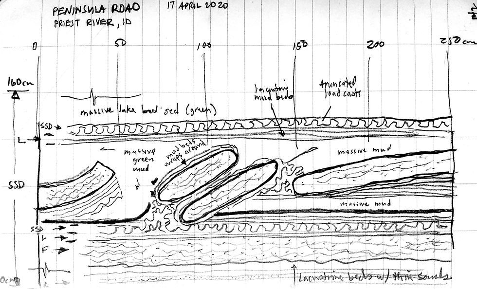
Field sketch of the excavation shown in photo above. Evidence of mass wasting is also prevalent lower in the section, where the sand beds are thicker. Exposure is 250cm wide x 160cm high.

Repeated, laterally-continuous zones of soft sediment deformation with large flame structures, load casts, rip-up clasts, and breccia are associated with sand deposition. Deformation is always bounded above and below by flat-lying lacustrine bedding. Interpretation: Glacial Priest Lake strata periodically interrupted by Missoula Floods. Flood-loading triggers mass wasting, which interrupts steady lake bottom deposition. Blocks of coherent strata come to rest in soupy muds, deforming them. Lake bottom deposition resumes after flooding ceases. Exposure is 3m wide and 1.75m high.

Pods of rip-up clasts of mudstone in sand. Or is it slide breccia?

Varved lake sediments are repeatedly disrupted by flood-deposited sand beds. "Stingy" and "generous" counts on varved intervals were made (i.e., Atwater's method for Sanpoil Valley). The southern portion of Priest River Valley, a proglacial lake basin, received waters from the east according to mapping by Breckenridge and Garwood (2019) and field evidence like this. I believe Priest River Valley contains the northeasternmost flood rhythmites.

Shiny gray-green varves and thicker orange sands near the top of the section. A thick brown sand caps the exposure.

Varves at Priest River look a lot like the varves at Banks Lake in the Upper Grand Coulee.
Richard Waitt investigated deposits in the Priest River Valley (Waitt, 1984), noting "16 or more" flood beds separated by varved intervals that correlate to similar lake-flood successions preserved at Latah Creek, in the Sanpoil Valley, and in the Upper Columbia River east of Grand Coulee,
Glacial Priest Lake, dammed in the Priest River valley by a tongue of the Purcell trench lobe of the Cordilleran ice sheet, generally accumulated varved mud; the varved mud is sharply interrupted by 14 sand beds deposited by upvalley-running currents. The sand beds are texturally and structurally similar to slackwater sediment in valleys in southern Washington that were backflooded by outbursts from glacial Lake Missoula. Beds of varved mud also accumulated in glacial Lake Spokane (or Columbia?) in Latah Creek valley and elsewhere in northeastern Washington; the mud beds were disrupted, in places violently, during emplacement of each of 16 or more thick flood-gravel beds. This history corroborates evidence from southern Washington that only one graded bed is deposited per flood, refuting a conventional idea that many beds accumulated per flood. The total number of such floodlaid beds in stratigraphic succession near Spokane is at least 28. The mud beds between most of the floodlaid beds in these valleys each consist of between 20 and 55 silt-to-clay varves. Lacustrine environments in northern Idaho and Washington therefore persisted for two to six decades between regularly recurring, colossal floods from glacial Lake Missoula.

E.H. Walker's original investigations took place somewhere near the slopes I excavated (Walker, 1967, Fig. 2). Local slopes and forests look different now. His caption reads, "Glacial-lake in the Priest River Valley, 3 miles north of the town of Priest River, Idaho. The dark layers are wet beds of sand and the light layers are mainly varved clay coated with dry overwash." Richard Waitt revisited Walker's outcrop (Waitt, 1985). The caption for his Figure 13 corrects Walker, "Beds of varved clay (dark bands) alternating with flood-laid beds of sand (light colored) in Priest River valley, northern Idaho. Eight flood-laid beds are visible, but entire section exposes 14 such beds."

Layering still stands out in weathered outcrops. Walker had it backwards. Waitt had it right. Dark layers are clayey varves. Light colored beds are sandy.

Sand bed deposited by an energetic flood deforms clay-rich quiet water varves beneath.

West Branch Priest River. Spectacular folds in slumped glaciolacustrine muds. Exposure is visible through openings in the trees across the valley from Hwy 57, but accessible from Peninsula Rd by hiking for 10 minutes downhill from large pullouts near the neck of the peninsula-like ridge (private land, ask permission, cross a short wall and a couple barb wire fences). Flat-lying lacustrine beds above and below the 3m-thick deformed zone. Not reported previously.

Another look at the lower part of the "rhythmite section" along West Branch Priest River (stratigraphically lower than Walker's outcrop) that may be the same indicated by Breckenridge (1989, Fig. 4). I counted about a dozen sand-varve intervals here and several more in exposures above this one. At the top of the section, I counted 6 more varve-sand intervals in a 3m-high excavation that lacked SSD altogether. So, around 30(?) lake-flood rhythmites are exposed along Peninsula Road, about twice as many found by Waitt (1984). Section might be duplicated by slide.

Slumped interval between flat-lying beds. In many places (textbooks for example), conspicuously deformed horizons like this would be called a "seismite", causing the hair of the neighborhood paleoseismologist to catch fire. "Call the newspaper! Call my agent! Tweet this out!" However, that interpretation would be presumptuous. Soft sed def is the norm in sedimentary sequences in proglacial lakes - glaciolacustrine sediments deposited in mountainous topography. Mean old Mr. Gravity just doing his thing again. #gobacktoseattle #sadfaceallthewayhome

Meter-scale folds in lacustrine muds. Looks like a local landslide at the dynamic margin of the former ice sheet. Probably not caused by an earthquake.

Its easy to lose track of what's come before in the Missoula floods game, especially when some of the older articles and field guides are not online.
Breckenridge (1989, Figure 4) identifies a "rhythmite section" (triangle symbol) northeast of Priest River, which is probably the scarp along the West Branch. Its unclear whether he ever formally described the section. I've not found anything. Maybe Dean knows. Maybe the IGS archives have something.

This map by Breckenridge (1989, Fig. 2) is an update of an earlier map by Richmond (1986). It shows the configuration of the Cordilleran Ice Sheet margin at Last Glacial Maximum. The town of Priest River is not shown, but it is located due east of Newport, just across the WA/ID border.

Map of post-basalt drainage pattern by Savage (1965, Fig. 21) in the vicinity of Priest River, ID. The stippled pattern shows "approximate boundaries of ponding and frequent flooding (Tertiary Lake Rathdrum)". I'm pretty sure Lake Rathdrum is not something geologists have continued to recognize, especially if its Tertiary. Sediments in the area are pretty much all Pleistocene, but, hey, it was the '60s and Savage was not going to be confined by tradition!

Glaciation of Bonner County, ID by Savage (1965, Fig. 15). According to the map, the Late Wisconsin Priest River Lobe covered most of the Priest River Valley (middle left). The ice margin was later refined by Waitt et al. (2016) and Breckenridge and Garwood (2019).

Excerpt of Waitt's map of the Priest Lake area from an FOP field guide (Waitt, 1983, Figure 3; Waitt 1985, Figure 13). His site first field stop in 1985 is the same as Walker's site on the Peninsula Rd (circled in red).
References
Atwater, B.F., 1986, Pleistocene Glacial-Lake Deposits of the Sanpoil River Valley, Northeastern Washington, U.S. Geological Survey Bulletin 1661
Breckenridge, R.M. (editor), 1989, Glacial Lake Missoula and the Channeled Scabland, 28th International Geological Congress Field Trip Guidebook T310, 72 pgs.
Breckenridge, R.M.; Garwood, D.L., 2019, Glacial geologic map of north Idaho, Ice Age Floods Institute Coeur Du Deluge Section/Keokee Press
Hanson, M.A.; Clague, J.J., 2016, Record of glacial Lake Missoula floods in glacial Lake Columbia, Washington, Quaternary Science Reviews, 133, p. 62-76
Savage, C.N., 1965, Geologic history of Pend Oreille Lake region in north Idaho, Idaho Bureau of Mines and Geology Pamphlet 134, 18 pgs. + figures.
Waitt, R.B., 1983, Tens of successive, colossal Missoula floods at north and east margins of Channeled Scabland, Friends of the Pleistocene Rocky Mountain Cell field guide/USGS Open-file Report 83-671, 29 pgs.


