
Pardee's Lens
- May 18, 2025
- 7 min read
Updated: Mar 16
If you've worked as a geologist in the West, it's a fairly safe bet that J.T. Pardee visited your field area decades before you arrived. Pardee, a geologist for the U.S. Geological Survey, traveled as far as his little Ford Model T could take him—to hard rock mines in the Rockies, oil prospects in the swamps of Florida, phosphate seams in Montana, fault scarps in the Basin and Range, and the desolate coulees of the Channeled Scablands. For more than 30 years, the government man journeyed along lonesome roads, traversed ridges, and slept under the open sky (with the obligatory stay at a hot spring resort on occasion). He endured the rugged, undeveloped Western landscape with remarkable style and grace—always in a collar and jacket, always working, and continually revisiting his own interpretations. Between 1910 and 1940, Pardee seemed to be everywhere, dedicating a season or two to one specific project before moving on to the next. Fellow geologists who crossed paths with him were often gifted his thoughts, notes, and maps. It seems he routinely handed over whatever he had on hand to colleagues, professors, and students who showed interest and a passion for fieldwork. Many of these beneficiaries would go on to write dissertations, amass fortunes, or build entire careers based on Pardee's insights and encouragement. A proud Montanan, Pardee was one of this country's greatest field geologists. While his writing, generosity, and influence are well known, his photography remains largely unrecognized. With this post, I hope to change that. Please enjoy this selection of images by Joseph Thomas Pardee, photographer.
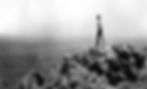
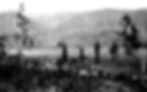
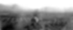
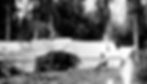
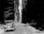
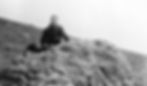
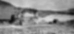
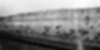
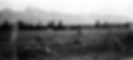
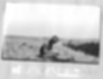
1918 - Stonehouse Quadrangle near Golconda, NV. Was the character James Arnold Ross in Upton Sinclair's book 'Oil!' inspired by this iconic photo? Or perhaps Daniel Plainview in Paul Thomas Anderson's film 'There Will Be Blood'.
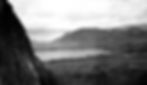
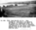
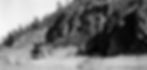
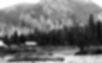
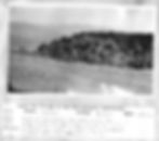
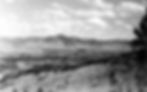
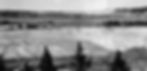
1917 - Osoyoos Lake, WA
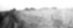
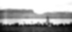
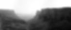
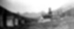
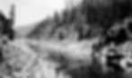
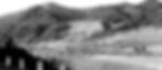
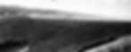
1917 - Steamboat Rock and Upper Grand Coulee, WA
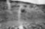
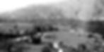
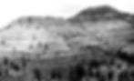
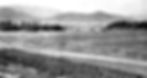
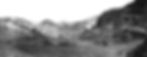
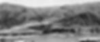
1921 - Rathdrum Prairie, WA
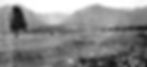
1921 - Years before J Harlan Bretz arrived on the scene, Pardee was documenting channeled "scab rock" coulees scoured clean by a great "Pleistocene river".
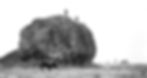
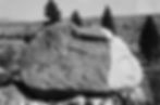
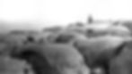
1918 - Haystack boulders on the Waterville Plateau near Mansfield, WA

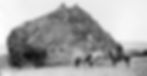
1922 - Pilot Rock erratic northwest of Coulee City in Upper Grand Coulee, WA
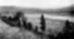
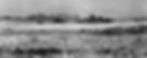
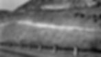
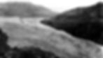
1922 - Outburst flood gravels at Ewan, WA, located some 40 miles south of Spokane, were interpreted by Pardee (and several others) as pre-Wisconsin drift

1918 - Weather erratics in the Anaconda Quadrangle, MT
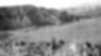
1921 - Moraine of an alpine glacier rests on the gravelly fan in the Jocko Valley west of Arlee, MT
1921 - Flat meadow occupies the drainage divide between the Jocko River and Clark Fork River at Evaro, MT
1921 - Cliffs of the Belt Formation along the Flathead River at Perma, MT
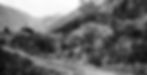
1921 - Chief Cliff above the village of Elmo, MT on the Big Arm of Flathead Lake
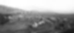
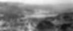
1912 - The community of Keller, WA on the Colville Indian Reservation is situated on a Pleistocene terrace along the Sanpoil River near a world-class, unmined molybdenum prospect at Mount Tolman
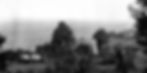
1917 - Pogue Flat at Omak, WA where I lived for five years
1910 - Basalt boulder resting on a gravel plain near Buffalo Lake, Colville Indian Reservation, WA
1910 - Haystack rock, Little Nespelem River Valley, Colville Indian Reservation, WA

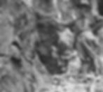
1910 - Granite boulder perched on a 2-foot tall pedestal of monzonite porrphyry, Stepstone Ck, Colville Indian Reservation, WA
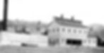
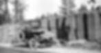
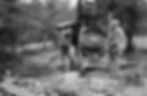
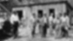
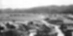
1910 - Keller & Indiana Consolidated Smelting Company, Sanpoil Valley, Colville Indian Reservation, WA
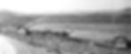
1910 - Whitestone Creek survey camp, Colville Indian Reservation, WA

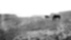
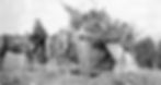
1910 - Barney the horse. One in a series of horse portraits that included Brownie, Cricket, Dollie, Baldy, Flaxie, Mollie, and Roan
1910 - Once exposed boulder bars at the Columbia River-Spokane River confluence, Colville Indian Reservation, WA
1910 - Town of Nespelem situated on a moraine near the Little Nespelem River, Colville Indian Reservation, WA
1910 - Columbia River Valley near mouth of Whitestone Creek, Colville Indian Reservation, WA

1910 - Moraine-dammed South Twin Lake from Wynecoop Rd, Colville Indian Reservation, WA
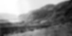
1910 - Sanpoil Volcanics fill the Republic Graben, Sanpoil Valley at West Fork Sanpoil/Gold Creek Rd, Colville Indian Reservation, WA
1910 - Mt. Ki-ki-yis, Sanpoil Valley at Bridge Creek, Colville Indian Reservation, WA
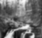
1910 - Falls of Hall Creek near Inchelium, Colville Indian Reservation, WA
1933 - Near Wilhelm cabin north of Douglas Creek, MT
Well into the 1930s, captions on official USGS photos reflect Pardee's hesitation in interpreting scoured bedrock, perched bars, elevated gravel deltas, mega ripples, and scabland in Clark Fork Valley, Flathead River Valley, Camas Prairie, and Markel Pass as flood-formed. He instead invoked an ancient "Dog Lake river" to explain what he observed.
1937 - Clark Fork River at White Pine, MT
1935 - USGS topographer surveying gold prospects at the Brewer Mine, Chesterfield County, SC

1931 - Columbia River Basalts in the Grand Ronde Valley near Ray's Ferry bridge, WA
1932 - Granite erratic in outwash on ridge northeast of Boulder Creek, Granite County, MT

1931 - Toe of the Nisqually glacier in Mt. Rainier National Park, WA

1931 - Thick pile of volcanic ash along the Enterprise-Lewiston Road, ID-WA border
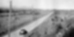
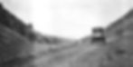
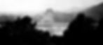
1924 - Roosevelt Highway near Lake Quinault, Olympic Peninsula, WA
Henry Creek Rd southeast of Plains, MT
1932 - Above the Ivor Johnson Ranch and the Flint Creek Valley between Maxville and Stone, MT
1921 - Glacially-steepened(?) walls of Belt bedrock along the Clark Fork River between Eddy and Weeksville, MT
1918 - Distinctive profiles of Canyon Creek and Blodgett Creek Valleys in the Bitterroot Mountains as seen from the irrigation canal serving Marcus Daly's 22,000-acre Bitter Root Stock Farm. Photo taken along Skalkaho Creek (Hwy 38) south of the Hamilton Golf Club, MT.
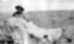
1921 - Field assistant in his university sweater atop a quartzite erratic at Butler Creek near Missoula, MT
1918 - Blackfoot Valley at Helmville, MT

1909 - Valley of Chimney Creek near Helmville, MT
1909 - Dixon Bench on the Flathead Indian Reservation, MT

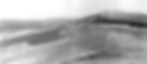
1917 - North Cascades above the Cascade River Valley, WA
1909 - Tuscor Hill near Trout Creek, MT
1918 - Brick furnace near Bonner, MT
1921 - "Durkin for Gin", Sunset Highway west of Spokane, WA
1921 - Rogers Pass, MT
1935 - Windy Hill, MT

1921 - Mission Range from near intersection of North Foothills Rd and Emory Rd east of Pablo, MT. My home is in the dark treeline, middle right.
1921 - Flathead River near Dixon, MT

1918 - Contorted bedding in sediments overridden by glacial ice at Lake Cushman west of Hoodsport, WA
1923 - Basalt columns along Sunset Highway west of Spokane, WA
1918 - Hwy 101 along Hood Canal at Hoodsport, WA
1909 - Gravel lenses interfinger with Glacial Lake Missoula lakebeds at DeSmet, MT and also near Drummond, MT
1921 - Buffalo Rapids below Polson on the Lower Flathead River, MT
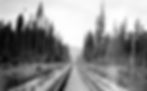
1921 - Great Northern Railway near Libby, MT
1917 - Diatomite in the American Mineral Products Company mine located a few miles south of Quincy, WA

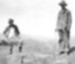
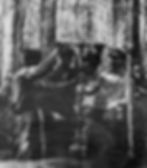
1921 - Alden and Pardee in Cascade County, MT
1917 - Potholes Coulee, WA

1921 - Pike's Peak ridge in the distance seen from Robinson Ridge west of Deer Lodge, MT
1918 - Future site of the legendary Stillwater Mine which still produces palladium and other platinum group metals (PGM) from the Johns-Manville Reef at Nye, MT
1918 - Field assistant(?) and weathered erratic near Deer Lodge, MT
1909 - Hellgate Coal Company's incline and coal bunkers at Missoula, MT
1921 - Snowy summits of Mt. Calowahcan (9065') and McDonald Peak (9820') in the Mission Range southeast of Ronan, MT
1926 - Continental Divide at Priest Pass west of Helena, MT
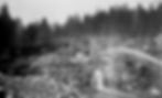
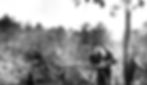
1918 - North Fork hydraulic mining for gold near Sumpter, OR
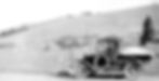
1924 - Oil drillers in a swamp east of Monticello, FL
1934 - Charles B. Johnson's one-man homemade gold mill near Rozzelle Bridge, NC
1918 - Geologist at the Rainier Quicksilver Mine in the Meadows District near Sumpter, OR

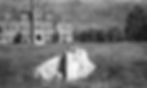
1921 - Glacier Park Lodge at the east entrance to Glacier National Park, MT
1918 - Half-buried erratic that still pokes up through the grass of the quad in front of University Hall at the University of Montana in Missoula
1937 - Dean Stone Peak, Council Hill, and the confluence of the Clark Fork and Bitterroot Rivers as seen from McCauley Butte west of Fort Missoula, MT
1918 - Was then and remains today the grubbiest town in the West - Cooke City, MT
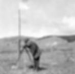
1924 - Pardee with plane table at Philipsburg, MT
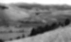
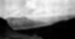
1940 - Glacial Lake Missoula shorelines above Camas Prairie, MT

1936 - Fault scarp cuts young alluvium at Lima, MT
1924 - Summit of Stewart Mountain above the Flint Creek Valley, MT

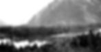
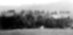
1924 - Gallatin Valley and Bridger Range, MT
1927 - South Fork of the Flathead River prior to the construction of Hungry Horse Dam, Flathead County, MT
1928 - Avalanche Gulch, Broadwater County, MT

1924 - Algonquin manganese mine at Philipsburg, MT
1934 - Survey geologists with hand bells at Battle Branch gold mine near Dahlonega, GA

1934 - Gold-bearing quartz veins at Pine Hill quarry, NC
1936 - Zortman, MT is a remote outpost in the Little Rocky Mountains
1938 - Dredge spoils of the Pioneer Mining Company in Gold Creek Valley, MT
1390 - Markel Pass, MT
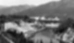
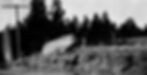
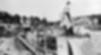
1936 - Town of Grand Coulee, WA during construction of the Grand Coulee Dam
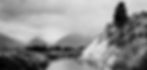
1929 - Beacon Rock in the Columbia Gorge, WA/OR
1935 - Placer gold processing apparatus, Powell County, MT
1938 - Fishing fleet and Indian village at Neah Bay, Olympic Peninsula, WA

1938 - Bluffs of glacial till (Flathead Lobe) capped by varved silts (Glacial Lake Missoula) along Flathead River at Sloan's Bridge, MT
1937 - Morainal deposits and haystack rocks at Del Rio west of Grand Coulee, WA
1937 - Little Bitterroot Valley west of Hotsprings, MT

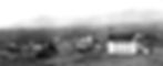
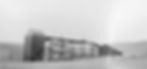
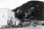
1936 - Town of Metaline Falls in the Pend Oreille Valley, WA with historic Lehigh Portland Cement Company building in the foreground and gabled Washington Hotel a few blocks behind.
1939 - Perched gravel bar ("gulch fill") along the Flathead River southeast of Paradise, MT
1938 - Boulder toppled from Ribbon Cliff near Entiat, WA
1938 - Volcanic ash exposed in roadcut south of Entiat, WA
1940 - Flathead River at the future site of the Hwy 382 bridge at Perma, MT taken from hill above stone quarry.
1940 - High level gravel deposit at Markel Pass, MT
1936 - Earth flow failure in an enormous spoils pile of Nespelem Silt excavated at Grand Coulee, WA
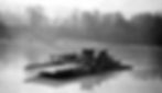
1926 - Ferry over the Skagit River, WA
1918 - Black Bear Claim near Green River, UT
Joseph T. Pardee, Field Geologist
Author's note - I selected the photos above from 8 digital photo albums hosted online by USGS/ScienceBase. I've cropped, sharpened, and adjusted the contrast on each. Dates on some photos appear to reflect the year the film was processed. Unless otherwise noted, most were taken in the prior year. Many can be tied directly to specific pages in Pardee's fieldbooks, which have been scanned and also reside in the USGS archives. Pardee often wrote "Photo" next to fieldbook entries.


