top of page

Swawilla Beach Geology

57 minutes ago
5 min read

Sixty miles south of the Republic Brewery is a perfect Sunday afternoon beach called Swawilla. Its a narrow stretch of sand and cobble that travels best in boots when its sunny. Cold weather or hot, the breeze will be with you either way, so prepare for it. Wear the right hat, your favorite jacket, and things will turn out okay.


This is Atwater Country. A vivid, rugged land where well-laid plans can change overnight. One day you're unraveling the history of Eocene mylonites, the next you're living in a vintage 53' Airstream studying Pleistocene lakebeds. But that's someone else's story.


Its Sunday and I'm here for the lakebeds, but may stay for the silence. As someone who's hiked a lot of Pacific beaches and inspected many miles of glacial deposits - Puget Sound, the San Juan Islands, and a bunch of shorelines in Canada and Alaska - I've grown to appreciate small crowds and less chatter. Swawilla Beach is a place where no crowds is the default. A place where you can get in touch with your inner geology hermit. There's lots to see in an hour or two. Treat the place with respect if you go. Its sacred to many who live here.

Swawilla Beach. A narrow, easily walkable strip that affords access to endless bluffs along a particularly lonesome reach of the Columbia River, just downstream from the mouth of the Sanpoil.

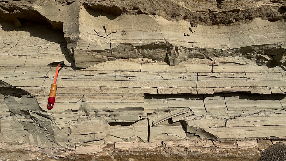
Today's goal. Learn more about the lakebeds of Glacial Lake Columbia and what's deformed them. Here they're flatlying and undisturbed, but that won't last long.

Hints of loading. Signs of rapid, subaqueous deposition and soft sediment deformation begin to appear just steps from the truck.

Downward loads and sideways flows. Loading of muddy, light-colored lakebeds by dark, coarse, sandy sediment deposited rapidly is accompanied by drag from strong currents and eddies. Its in the lakebeds where we can see best what's happened. Pinched strata, rising dikes, stratified lath-shaped rip-ups, and wholesale disaggregation are a few things that fans of the Missoula floods tend to look for.
Deformation confined. When I see flame structures, I immediately look at the bedding above and below. Is it deformed or not? Beds that confine the deformed interval (contain flame structures) lie flat. The deformation is constrained in time, as quiet sedimentation resumed afterward. Specific events like this can sometimes be dated.
That really got out of hand fast. Its won't take long for the trained eye - and most untrained eyes - to determine that there's something funny going on with the sediments exposed in shoreline bluffs near the mouth of the Sanpoil River.

Cemented foresets in sand. Meter-scale bedforms attest to big water moving fast. Here, time and a little calcium carbonate have helped preserve the planar foresets in coarse sand deposited by a Missoula flood. The coarsest portions seem to have attracted more cement and stand proud of the rest, at least for now. November's rain will surely knock them back a bit.

Swale or slide block? At first glance, this feature looks like a typical channel scour. But look closer. The tilted beds that fill the "swale" are lake bottom silts and clays - the very finest grained sediment there is. Its the kind of stuff that only settles out of suspension after many hours if not days. Unlike sand, clayey-silts don't lay down any way but flat. Nevertheless, its resting on a sloping surface. What gives?

Pop quiz. Try your hand at interpreting the depositional environment of the 5 layers. You may need to draw some limes. Locate the deformation features. What's in place and what's out of place? Can you identify a few potential triggers for the deformation?

Clastic dikes of a different sort. Clastic dikes formed in Ice Age muds deposited on the bottom of Glacial Lake Columbia differ considerably from the wedge-shaped, sand-filled, sheeted features common in slackwater deposits in the Channeled Scablands. Up here, the dikes take the form of large flame structures, or as Brian Atwater calls them, T-shaped mud squirts. They are products of rapid loading by water and sediment. The example above is typical. It rises vertically from a deformed and thickened bed, then goes sideways as its top flops over in the downstream direction. The dike pinches out a few meters past the flop.
Getting squirly. A thickened band of lakebeds gives rise to another dike, itself thicker and more complex than its source. They clayey-silty beds are stiff and hang together well, piling up as hydraulic forces shove them upward.

Same dike. The dike doesn't penetrate the cobbly terrace gravel above. In fact, the gravel truncates it, which means the dike-triggering event ceased prior to deposition of the gravel.
Thick or thin. Mud squirt dikes composed of lake bottom sediment take different shapes and sometimes rise along small normal faults that cut through the sediment pile. Other times, they rise for reasons that are less clear.
Normal faults. Normal faults offset layers by a few tens of centimeters. Small-offset faults like these are not rare in the area, but they are not often well displayed. We're lucky that the outcrop is in such good shape today. Normal faults are a common way rocks and sediments respond to extension. What's the orientation of the maximum and minimum principle stresses?

Slumps lead to truncation and transport. This block of lakebeds is fully detached from its moorings. Its a mega-sized rip-up clast completely surrounded by coarse sand. I like the term 'lath' to describe elongate, stratified chunks like this.

Wholesale disaggregation. Strong currents tend to tear laths to pieces. Its common to find large, floating chunks surrounded by innumerable chips downstream of intact bedding or detached blocks. All three forms occupy the same stratigraphic horizon.

Mud founders, students flounder. I took college courses with a guy named Flounder and another one named Squid. Both are lawyers now.

Straight fault and twisty mud. Deformation here nucleates on a couple of small, conjugate normal faults. These muddy, upward-pinching dikes can be found by the dozens along this stretch of shoreline.

Mystery of the sunburnt stones. Farther down the shoreline, a completely different geological mystery awaits you. A line of sun-reddened cobbles extends for more than 100m into the distance. The stoneline forms a cap on a debris flow-like gravel unit (Gravel A) that appears to incise into the terrace. I suspect the gravel originated in an upland gully that washed out in a storm and spilled cobbles into the river. I interpret the sunburn (i.e., desert varnish) to represent a period of extended exposure at the surface. The debris flow cobbles appear to have laid unburied for a considerable amount of time. Eventually, fluvial deposits covered them up, but it took a while. The question is how long did the stones sit out in the open before they obtained such a thorough tan? Like 200 years or 2000?
Weathering in three acts. Three nearly identical basaltic andesites - one fresh, one medium rare, one well done. Iron in the form of hematite is doing most of the work, perhaps with a bit of manganese.
Stratigraphy of a stoneline. Unraveling gritty mysteries is what geologists think is fun. And by 'unraveling', I mean drawing yellow lines on photographs. Deep down we're all trying to be more like Gary Paull.

Soil profile below stoneline. I see a B-horizon beneath the line of sunburnt cobbles.

Go wide for stratigraphic context. Lakebeds of Pleistocene Glacial Lake Columbia, Missoula flood deposits, and a cobbly, terrestrial debris flow comprise the lower half of the exposure. Terrace gravels and associated overbank sands of the Columbia-Sanpoil River confluence bury them all. Later, Holocene sand dunes marched over top. Have a good week!


Last 50 Posts
All Posts by Month
    bottom of page