Clastic Dikes Literature Relevant to Eastern Washington 1820-2020

Fieldwork in Burlingame Canyon near Walla Walla in July 1995.

Several dozen articles, abstracts, consultant reports, and field guides have been published on the clastic dikes in Eastern Washington between 1925-2020. Ninety-four are shown here. Very few contain measurements on dikes or data of any kind.

Usage of the terms "clastic dike", "clastic dyke", and "seismite" according to Google Books Ngram database. Peaks in usage correspond with early discoveries of dikes (1910s), mid-century field research and post-WWII construction of large industrial facilities (1940-50s), publication of lab-based liquefaction studies by engineers (1960-70s), and investigations by a newly minted discipline/industry we know today as Paleoseismology (1980s-90s).
My review and commentary on several dozen articles on the clastic dikes in Eastern Washington and adjacent portions of Oregon and Idaho. Your comments always welcome: skyecooley@gmail.com.
Sixteen clastic dikes were observed, photographed, and described in the enormous ERDF excavation. This report is nearly impossible to find in libraries or online, though it is cited several times in a 1996 Final EIS on waste tanks at Hanford. I had to make an Administrative Records request to obtain a copy. Language in the report appears borrowed from Cooley et al. (1996). Report contains no relevant references. A classic Hanford report by Karl Fecht, one of its dimmer lights.

Early mention of aseismic deformation in the Touchet Beds appears in J Harlan Bretz's archived field notes (August 14, 1923) and in one other publication (Bretz, 1928b, Fig. 9 photo). His fieldwork was contemporary with that of Olaf P. Jenkins and Israel C. Russell, but a full decade before Richard Foster Flint paid Eastern Washington a visit in the mid-1930s.
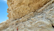
The caption for the 1928 photo above reads,
Contorted bedding in silt and fine sand, Walla Walla Valley. Etched into relief by the wind.
In the body of the article, he notes,
Marked irregularities in stratification of sandy phases occur. One such structure is illustrated in Figure 9. No satisfactory explanation for this is at hand.
In 1923, Bretz writes,
Along Sunset Hiway, 4-5 miles north of Wenatchee, is a cut showing a seasonably banded silt about 200 ft above the altitude of Wenatchee. 30-foot section. Silt is pale buff in color. Some portions a very fine sand, somewhat more gray or brown colored. The seasonal banding is far from perfect thruout...In most summer bands, is a delicate foreset or current bedding, showing very gentle southward drift of the material along the bottom. This doesn't seem right for a water body which recorded varve clays. And there are several other unorthodox things too. Portions of the deposit which do not show varve clay straification are composed of fine sand to silt, not of clay. Current bedding is prominent in this, much more so than in the summer varves. Here and there in the section are worn pebbles and cobble not of basalt or the local granite. These undoubtedly show the presence of floating ice. In certain layer of the finer silt are most peculiar contortions of the laminae, tho the strat immediately above or below are not affected. Some of these contortions were sketched. In each sketch, one prominet continuous lamina has been shown. The others are squeezed or thickened to conform. In [sketch 3] the little triangular areas show fragmentation and porosity. These plications or contortions have a strike. They are rolls! And the strike is essentially parallel to the wall of the valley here. Other evidence, in the existence of gentle flexures in the strata themselves, seems to point to settling of the material down a subaqueous slope toward the deeper parts of the valley as the cause for the distortion.
Bretz's only mention of clastic dikes arrives on July 15, 1929 in typed field notes on Tammany Bar at Lewiston, ID. This is four years after publication of the first article on Touchet Bed clastic dikes by O.P. Jenkins, who visited this same exposure. At Lewiston, Touchet Beds ("silts") overlie a boulder gravel bar left by the Bonneville flood.
The silt rests directly on the rough bouldery surface of the gravel deposit, some boulders a foot or two in diameter setting up on top of the gravel project for their full diameter into the silt...The silt is well sorted, no scattered particle of basalt, etc., rather irregular bedding. Lenses of black coarse sand occur irregularly, the contact of sand on silt being so irregular that it seems like a cross section of miniature mountain topography. To add to the puzzle, clastic dikes can be traced up in the depsit, thickenin with increasing height and some of them abruptly ending at various levels. This silt looks more like a normal stream alluvium, the cracks developing at successive interevals while the accumulation was going on per saltum, thus some of the cracks being filled and covered over before other cracks were formed. Yet there is no such sand on top of the silt today from which the the major number of the cracks (coming to the top) could be filled. Such sand deposit may once have been present, and now gone by erosion.

Intermountain Motorist, September 1928.